Jesús María night lights from space
Night Light of Jesús María (Jalisco) from space (Mexico) Src. Average luminocity for 10x10km area is 7.6591% and for 50x50km: 4.8194%.
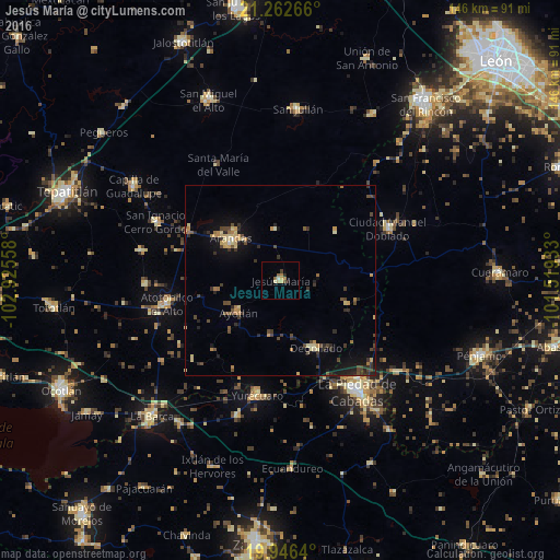
Analysis of Jesús María night lights 2016
Square area 10x10 km:
 0%
0%90-99
1.14%80-89
2.27%70-79
0.38%60-69
1.52%50-59
1.52%40-49
0.76%30-39
0.76%20-29
1.52%10-19
0%0-9
90.15%Square area 50x50 km:
0.02%90-99
0.16%80-89
1.05%70-79
0.61%60-69
0.71%50-59
0.34%40-49
1.38%30-39
1.05%20-29
1.36%10-19
2.7%0-9
90.61%Clear (daylight) street map image can be seen on geolist.org.
Map coordinates:
21° 15' 45.6" North, 102° 55' 32.1" West
20° 36' 21.4" North, 102° 13' 20.8" West
19° 56' 47" North, 101° 31' 9.6" West
Some cities around Jesús María sort by population:
• La Piedad
35.5 km =22.1 mi,  145°
145°
• Arandas
17 km =10.6 mi,  310°
310°
• Atotonilco el Alto
30.5 km =19 mi,  258°
258°
• Yurécuaro
30.7 km =19.1 mi,  192°
192°
• Ciudad Manuel Doblado
31.3 km =19.4 mi,  64°
64°
• Ayotlán
13.8 km =8.6 mi,  231°
231°
• Degollado
17.2 km =10.7 mi, 153°
• La Ribera
29.2 km =18.1 mi, 192°
4004004 (p: 8,249)
Sources (retrieved 2019-11-25):
» Earth at Night: Flat Maps 2012, 2016