Santa Ana Nopalucan night lights from space
Night Light of Santa Ana Nopalucan (Tlaxcala) from space (Mexico) Src. Average luminocity for 10x10km area is 59.9762% and for 50x50km: 45.8168%.
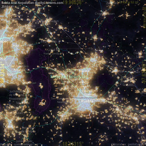
Analysis of Santa Ana Nopalucan night lights 2016
Square area 10x10 km:
 0%
0%90-99
0.87%80-89
20.78%70-79
8.23%60-69
14.07%50-59
17.75%40-49
30.95%30-39
7.36%20-29
0%10-19
0%0-9
0%Square area 50x50 km:
4.63%90-99
5.54%80-89
13.53%70-79
9.2%60-69
7.68%50-59
6.55%40-49
7.64%30-39
4.92%20-29
6.44%10-19
10.17%0-9
23.72%Clear (daylight) street map image can be seen on geolist.org.
Map coordinates:
19° 57' 37.3" North, 99° 2' 10.8" West
19° 17' 53.2" North, 98° 19' 59.6" West
18° 37' 59.3" North, 97° 37' 48.3" West
Some cities around Santa Ana Nopalucan sort by population:
• Moyotzingo
9.4 km =5.8 mi,  233°
233°
• Acuitlapilco
10.6 km =6.6 mi,  105°
105°
• Tepetitla
5.8 km =3.6 mi, 231°
• Panotla
6.9 km =4.3 mi,  73°
73°
• Totolac
8.4 km =5.2 mi, 68°
• Villa Mariano Matamoros
5.7 km =3.5 mi,  303°
303°
• Villa Alta
7.2 km =4.5 mi,  265°
265°
• San Damián Texoloc
5.5 km =3.4 mi, 113°
3815433 (p: 6,848)
Sources (retrieved 2019-11-25):
» Earth at Night: Flat Maps 2012, 2016