Villa Alta night lights from space
Night Light of Villa Alta (Tlaxcala) from space (Mexico) Src. Average luminocity for 10x10km area is 67.6126% and for 50x50km: 38.8303%.
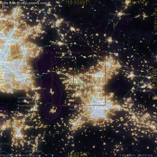
Analysis of Villa Alta night lights 2016
Square area 10x10 km:
 4.55%
4.55%90-99
8.23%80-89
24.03%70-79
9.96%60-69
19.91%50-59
9.96%40-49
13.42%30-39
5.41%20-29
4.55%10-19
0%0-9
0%Square area 50x50 km:
4.03%90-99
4.42%80-89
10.94%70-79
7.8%60-69
6.37%50-59
5.84%40-49
6.85%30-39
4.13%20-29
5.45%10-19
9.01%0-9
35.15%Clear (daylight) street map image can be seen on geolist.org.
Map coordinates:
19° 57' 17.7" North, 99° 6' 15.2" West
19° 17' 33.5" North, 98° 24' 4" West
18° 37' 39.6" North, 97° 41' 52.7" West
Some cities around Villa Alta sort by population:
• San Martin Texmelucan de Labastida
4.1 km =2.5 mi,  256°
256°
• Moyotzingo
5 km =3.1 mi,  184°
184°
• Santa Ana Xalmimilulco
9.1 km =5.7 mi,  167°
167°
• San Rafael Tlanalapan
7 km =4.3 mi,  269°
269°
• San Lucas el Grande
8.2 km =5.1 mi,  280°
280°
• Tepetitla
4 km =2.5 mi,  139°
139°
• Santa Ana Nopalucan
7.2 km =4.5 mi,  85°
85°
• San Juan Tuxco
6.5 km =4 mi,  235°
235°
3815444 (p: 5,974)
Sources (retrieved 2019-11-25):
» Earth at Night: Flat Maps 2012, 2016