Panotla night lights from space
Night Light of Panotla (Tlaxcala) from space (Mexico) Src. Average luminocity for 10x10km area is 70.4442% and for 50x50km: 44.5009%.
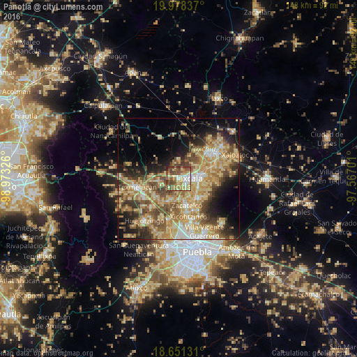
Analysis of Panotla night lights 2016
Square area 10x10 km:
 7.23%
7.23%90-99
10.95%80-89
20.45%70-79
14.46%60-69
11.36%50-59
16.12%40-49
16.53%30-39
2.27%20-29
0.62%10-19
0%0-9
0%Square area 50x50 km:
3.03%90-99
4.92%80-89
13.52%70-79
9.49%60-69
8.17%50-59
6.68%40-49
8.22%30-39
5.3%20-29
6.54%10-19
9.46%0-9
24.68%Clear (daylight) street map image can be seen on geolist.org.
Map coordinates:
19° 58' 42.1" North, 98° 58' 23.7" West
19° 18' 58.3" North, 98° 16' 12.5" West
18° 39' 4.7" North, 97° 34' 1.2" West
Some cities around Panotla sort by population:
• Tlaxcala
7.4 km =4.6 mi,  87°
87°
• La Magdalena Tlaltelulco
8.6 km =5.3 mi,  115°
115°
• Acuitlapilco
6 km =3.7 mi,  142°
142°
• Totolac
1.6 km =1 mi,  49°
49°
• Santa Ana Nopalucan
6.9 km =4.3 mi,  253°
253°
• San Esteban Tizatlán
6.4 km =4 mi,  66°
66°
• Santa María Ixtulco
6.6 km =4.1 mi,  81°
81°
• San Damián Texoloc
4.5 km =2.8 mi,  200°
200°
3521951 (p: 7,356)
Sources (retrieved 2019-11-25):
» Earth at Night: Flat Maps 2012, 2016