Tepetitla night lights from space
Night Light of Tepetitla (Tlaxcala) from space (Mexico) Src. Average luminocity for 10x10km area is 66.868% and for 50x50km: 44.5041%.
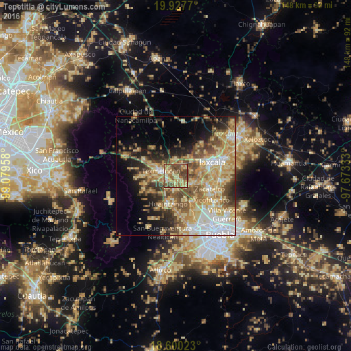
Analysis of Tepetitla night lights 2016
Square area 10x10 km:
 0.65%
0.65%90-99
6.28%80-89
27.71%70-79
9.09%60-69
18.83%50-59
16.45%40-49
16.02%30-39
4.98%20-29
0%10-19
0%0-9
0%Square area 50x50 km:
6%90-99
5.58%80-89
12.24%70-79
8.57%60-69
7.09%50-59
6.1%40-49
7.33%30-39
4.62%20-29
5.81%10-19
9.17%0-9
27.48%Clear (daylight) street map image can be seen on geolist.org.
Map coordinates:
19° 55' 39.7" North, 99° 4' 46.5" West
19° 15' 55.1" North, 98° 22' 35.2" West
18° 36' 0.8" North, 97° 40' 24" West
Some cities around Tepetitla sort by population:
• San Martin Texmelucan de Labastida
6.9 km =4.3 mi,  287°
287°
• Moyotzingo
3.5 km =2.2 mi,  237°
237°
• Santa Ana Xalmimilulco
5.9 km =3.7 mi,  185°
185°
• Santa Ana Nopalucan
5.8 km =3.6 mi,  51°
51°
• Villa Mariano Matamoros
6.8 km =4.2 mi,  358°
358°
• San Juan Tuxco
7.9 km =4.9 mi,  265°
265°
• Villa Alta
4 km =2.5 mi,  319°
319°
• San Damián Texoloc
9.7 km =6 mi,  81°
81°
3515870 (p: 8,316)
Sources (retrieved 2019-11-25):
» Earth at Night: Flat Maps 2012, 2016