San Marcos Yachihuacaltepec night lights from space
Night Light of San Marcos Yachihuacaltepec (México) from space (Mexico) Src. Average luminocity for 10x10km area is 84.1715% and for 50x50km: 38.0538%.
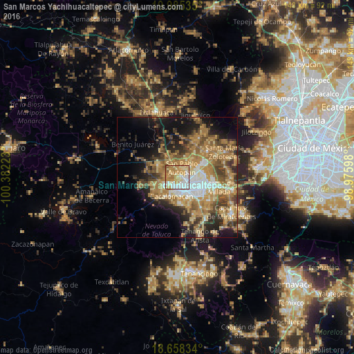
Analysis of San Marcos Yachihuacaltepec night lights 2016
Square area 10x10 km:
 22.93%
90-99
13.22%80-89
25.41%70-79
21.49%60-69
14.67%50-59
2.27%40-49
0%30-39
0%20-29
0%10-19
0%0-9
0%Square area 50x50 km:
4.26%90-99
4.21%80-89
6.38%70-79
8.02%60-69
11.05%50-59
5.39%40-49
6.01%30-39
4.59%20-29
7.05%10-19
11.51%0-9
31.51%Clear (daylight) street map image can be seen on geolist.org.
Map coordinates:
19° 59' 7.3" North, 100° 22' 56" West
19° 19' 23.5" North, 99° 40' 44.8" West
18° 39' 30" North, 98° 58' 33.5" West
Some cities around San Marcos Yachihuacaltepec sort by population:
• Toluca
4.8 km =3 mi,  145°
145°
• San Pablo Autopan
4.3 km =2.7 mi,  31°
31°
• San Andrés Cuexcontitlán
7.2 km =4.5 mi,  56°
56°
• San Buenaventura
6.4 km =4 mi,  174°
174°
• Calixtlahuaca
1.8 km =1.1 mi,  324°
324°
• Santiaguito Tlalcilalcalli
5.4 km =3.4 mi,  290°
290°
• Conjunto Urbano la Loma I
5.6 km =3.5 mi,  273°
273°
• Jicaltepec Autopan
6.7 km =4.2 mi,  36°
36°
3827252 (p: 5,917)
Sources (retrieved 2019-11-25):
» Earth at Night: Flat Maps 2012, 2016