Calixtlahuaca night lights from space
Night Light of Calixtlahuaca (México) from space (Mexico) Src. Average luminocity for 10x10km area is 77.3368% and for 50x50km: 37.8013%.
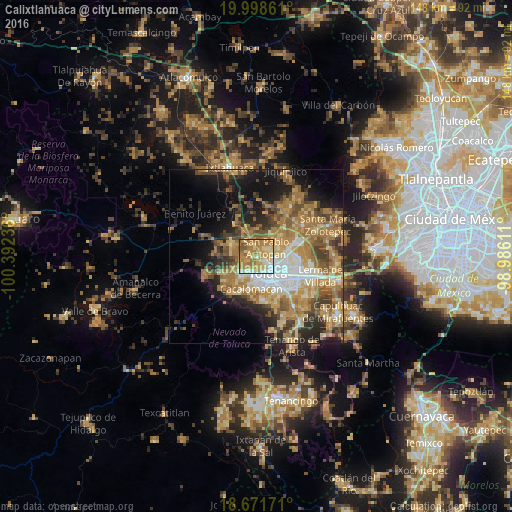
Analysis of Calixtlahuaca night lights 2016
Square area 10x10 km:
 8.47%
8.47%90-99
9.09%80-89
23.76%70-79
24.79%60-69
27.69%50-59
5.17%40-49
1.03%30-39
0%20-29
0%10-19
0%0-9
0%Square area 50x50 km:
4.26%90-99
4.15%80-89
6.39%70-79
8%60-69
10.88%50-59
5.36%40-49
6.07%30-39
4.48%20-29
6.91%10-19
11.41%0-9
32.09%Clear (daylight) street map image can be seen on geolist.org.
Map coordinates:
19° 59' 55" North, 100° 23' 32.5" West
19° 20' 11.4" North, 99° 41' 21.2" West
18° 40' 18.2" North, 98° 59' 10" West
Some cities around Calixtlahuaca sort by population:
• Toluca
6.6 km =4.1 mi,  145°
145°
• San Pablo Autopan
4 km =2.5 mi,  56°
56°
• Santiaguito Tlalcilalcalli
4 km =2.5 mi,  276°
276°
• Fraccionamiento Colinas del Sol
6.7 km =4.2 mi,  306°
306°
• La Cabecera
6.5 km =4 mi,  289°
289°
• Conjunto Urbano la Loma I
4.6 km =2.9 mi,  255°
255°
• San Marcos Yachihuacaltepec
1.8 km =1.1 mi,  144°
144°
• Jicaltepec Autopan
6.4 km =4 mi,  52°
52°
3531794 (p: 8,993)
Sources (retrieved 2019-11-25):
» Earth at Night: Flat Maps 2012, 2016