Conjunto Urbano la Loma I night lights from space
Night Light of Conjunto Urbano la Loma I (México) from space (Mexico) Src. Average luminocity for 10x10km area is 70.0661% and for 50x50km: 33.2887%.
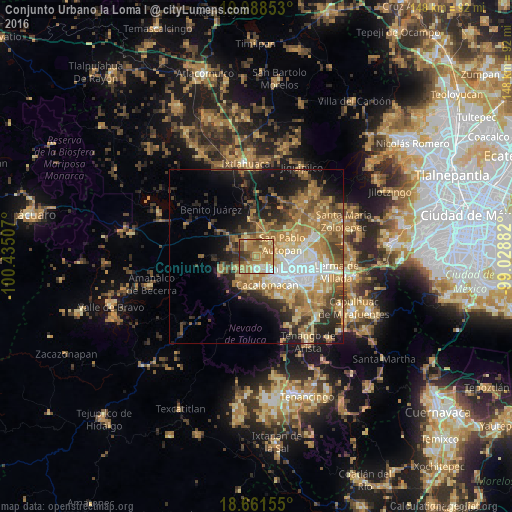
Analysis of Conjunto Urbano la Loma I night lights 2016
Square area 10x10 km:
 5.58%
5.58%90-99
7.44%80-89
15.5%70-79
18.39%60-69
32.44%50-59
9.3%40-49
6.2%30-39
4.96%20-29
0.21%10-19
0%0-9
0%Square area 50x50 km:
4.11%90-99
3.75%80-89
5.39%70-79
6.94%60-69
8.95%50-59
4.72%40-49
5.04%30-39
4%20-29
6.78%10-19
10.71%0-9
39.59%Clear (daylight) street map image can be seen on geolist.org.
Map coordinates:
19° 59' 18.7" North, 100° 26' 6.3" West
19° 19' 35" North, 99° 43' 55" West
18° 39' 41.6" North, 99° 1' 43.8" West
Some cities around Conjunto Urbano la Loma I sort by population:
• Zinacantepec
4.7 km =2.9 mi,  182°
182°
• San Francisco Tlalcilalcalpan
5.1 km =3.2 mi,  226°
226°
• Calixtlahuaca
4.6 km =2.9 mi,  75°
75°
• Santiaguito Tlalcilalcalli
1.6 km =1 mi,  17°
17°
• Ejido San Lorenzo Cuauhtenco
3.4 km =2.1 mi,  214°
214°
• Fraccionamiento Colinas del Sol
5.2 km =3.2 mi,  350°
350°
• La Cabecera
3.7 km =2.3 mi,  332°
332°
• San Marcos Yachihuacaltepec
5.6 km =3.5 mi,  93°
93°
8858224 (p: 6,192)
Sources (retrieved 2019-11-25):
» Earth at Night: Flat Maps 2012, 2016