Jicaltepec Autopan night lights from space
Night Light of Jicaltepec Autopan (México) from space (Mexico) Src. Average luminocity for 10x10km area is 73.8099% and for 50x50km: 41.6956%.
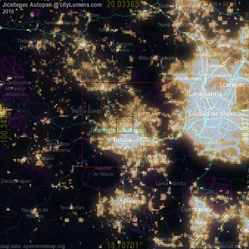
Analysis of Jicaltepec Autopan night lights 2016
Square area 10x10 km:
 3.72%
3.72%90-99
10.54%80-89
23.35%70-79
25.62%60-69
20.66%50-59
7.44%40-49
5.99%30-39
2.07%20-29
0.62%10-19
0%0-9
0%Square area 50x50 km:
4.31%90-99
4.38%80-89
6.6%70-79
8.84%60-69
12.36%50-59
5.78%40-49
7.42%30-39
5.39%20-29
8.96%10-19
13.21%0-9
22.75%Clear (daylight) street map image can be seen on geolist.org.
Map coordinates:
20° 2' 1.1" North, 100° 20' 38.3" West
19° 22' 18" North, 99° 38' 27" West
18° 42' 25.2" North, 98° 56' 15.8" West
Some cities around Jicaltepec Autopan sort by population:
• San Pablo Autopan
2.4 km =1.5 mi,  225°
225°
• San José Guadalupe Otzacatipan
5.9 km =3.7 mi,  120°
120°
• San Mateo Otzacatipan
5.8 km =3.6 mi,  137°
137°
• San Andrés Cuexcontitlán
2.5 km =1.6 mi, 124°
• Calixtlahuaca
6.4 km =4 mi, 232°
• San Nicolás Tolentino
7.4 km =4.6 mi,  101°
101°
• San Marcos Yachihuacaltepec
6.7 km =4.2 mi,  216°
216°
• San Miguel Totoltepec
8.5 km =5.3 mi,  128°
128°
8858257 (p: 5,228)
Sources (retrieved 2019-11-25):
» Earth at Night: Flat Maps 2012, 2016