San Buenaventura night lights from space
Night Light of San Buenaventura (México) from space (Mexico) Src. Average luminocity for 10x10km area is 89.0043% and for 50x50km: 37.633%.
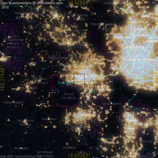
Analysis of San Buenaventura night lights 2016
Square area 10x10 km:
 37.88%
90-99
21%80-89
15.8%70-79
15.58%60-69
6.49%50-59
1.95%40-49
0.87%30-39
0.22%20-29
0.22%10-19
0%0-9
0%Square area 50x50 km:
4.23%90-99
4.18%80-89
6.47%70-79
8.01%60-69
10.99%50-59
5.29%40-49
5.87%30-39
4.53%20-29
6.81%10-19
10.36%0-9
33.27%Clear (daylight) street map image can be seen on geolist.org.
Map coordinates:
19° 55' 42" North, 100° 22' 35.2" West
19° 15' 57.4" North, 99° 40' 24" West
18° 36' 3.1" North, 98° 58' 12.7" West
Some cities around San Buenaventura sort by population:
• Toluca
3.2 km =2 mi,  40°
40°
• San Francisco Cuaxusco
5.7 km =3.5 mi,  88°
88°
• San Jorge Pueblo Nuevo
5 km =3.1 mi,  105°
105°
• Santiago Tlacotepec
4.3 km =2.7 mi,  176°
176°
• Cacalomacan
3.7 km =2.3 mi,  247°
247°
• San Felipe Tlalmimilolpan
4.4 km =2.7 mi,  132°
132°
• San Juan Tilapa
5.3 km =3.3 mi,  164°
164°
• San Antonio Buenavista
4.1 km =2.5 mi,  262°
262°
3519601 (p: 9,991)
Sources (retrieved 2019-11-25):
» Earth at Night: Flat Maps 2012, 2016