San Andrés Cuexcontitlán night lights from space
Night Light of San Andrés Cuexcontitlán (Morelos) from space (Mexico) Src. Average luminocity for 10x10km area is 83.1054% and for 50x50km: 43.058%.
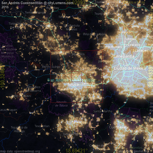
Analysis of San Andrés Cuexcontitlán night lights 2016
Square area 10x10 km:
 13.84%
90-99
21.9%80-89
23.14%70-79
22.31%60-69
16.74%50-59
1.24%40-49
0.83%30-39
0%20-29
0%10-19
0%0-9
0%Square area 50x50 km:
4.33%90-99
4.39%80-89
7.03%70-79
8.87%60-69
12.77%50-59
6.1%40-49
7.59%30-39
5.77%20-29
10.06%10-19
13.83%0-9
19.27%Clear (daylight) street map image can be seen on geolist.org.
Map coordinates:
20° 1' 15.3" North, 100° 19' 28.7" West
19° 21' 32.1" North, 99° 37' 17.4" West
18° 41' 39.2" North, 98° 55' 6.2" West
Some cities around San Andrés Cuexcontitlán sort by population:
• San Pablo Autopan
3.8 km =2.4 mi,  265°
265°
• San José Guadalupe Otzacatipan
3.5 km =2.2 mi,  116°
116°
• San Mateo Otzacatipan
3.5 km =2.2 mi,  146°
146°
• Santa María Totoltepec
6.6 km =4.1 mi, 152°
• San Nicolás Tolentino
5.2 km =3.2 mi,  90°
90°
• San Marcos Yachihuacaltepec
7.2 km =4.5 mi,  236°
236°
• San Miguel Totoltepec
6 km =3.7 mi,  130°
130°
• Jicaltepec Autopan
2.5 km =1.6 mi,  304°
304°
3827248 (p: 18,005)
Sources (retrieved 2019-11-25):
» Earth at Night: Flat Maps 2012, 2016