San Julián night lights from space
Night Light of San Julián (Jalisco) from space (Mexico) Src. Average luminocity for 10x10km area is 9.7976% and for 50x50km: 2.5765%.
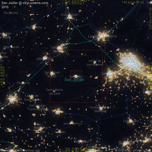
Analysis of San Julián night lights 2016
Square area 10x10 km:
 0%
0%90-99
1.59%80-89
2.98%70-79
0.79%60-69
2.38%50-59
0.4%40-49
1.39%30-39
1.39%20-29
2.38%10-19
0.2%0-9
86.51%Square area 50x50 km:
0.01%90-99
0.33%80-89
0.59%70-79
0.38%60-69
0.33%50-59
0.15%40-49
0.49%30-39
0.43%20-29
0.54%10-19
0.95%0-9
95.8%Clear (daylight) street map image can be seen on geolist.org.
Map coordinates:
21° 39' 55" North, 102° 52' 58.1" West
21° 0' 37.3" North, 102° 10' 46.8" West
20° 21' 9.1" North, 101° 28' 35.6" West
Some cities around San Julián sort by population:
• San Francisco del Rincón
33.7 km =20.9 mi,  88°
88°
• Arandas
38.1 km =23.7 mi,  207°
207°
• Purísima de Bustos
31.4 km =19.5 mi, 85°
• Jalostotitlán
34.3 km =21.3 mi,  300°
300°
• San Miguel el Alto
23.4 km =14.5 mi,  275°
275°
• Ciudad Manuel Doblado
39.2 km =24.4 mi,  142°
142°
• Unión de San Antonio
22.2 km =13.8 mi,  54°
54°
• San Diego de Alejandría
19.2 km =11.9 mi,  95°
95°
3985797 (p: 12,949)
Sources (retrieved 2019-11-25):
» Earth at Night: Flat Maps 2012, 2016