Ciudad Manuel Doblado night lights from space
Night Light of Ciudad Manuel Doblado (Guanajuato) from space (Mexico) Src. Average luminocity for 10x10km area is 14.0568% and for 50x50km: 2.9013%.
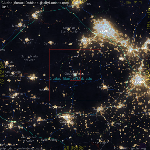
Analysis of Ciudad Manuel Doblado night lights 2016
Square area 10x10 km:
 0.76%
0.76%90-99
1.89%80-89
2.84%70-79
0.57%60-69
0.76%50-59
3.03%40-49
5.11%30-39
2.46%20-29
1.33%10-19
1.52%0-9
79.73%Square area 50x50 km:
0.03%90-99
0.11%80-89
0.48%70-79
0.32%60-69
0.39%50-59
0.38%40-49
1.01%30-39
0.59%20-29
0.62%10-19
1.44%0-9
94.62%Clear (daylight) street map image can be seen on geolist.org.
Map coordinates:
21° 23' 6.2" North, 102° 39' 19.4" West
20° 43' 44" North, 101° 57' 8.1" West
20° 4' 11.5" North, 101° 14' 56.9" West
Some cities around Ciudad Manuel Doblado sort by population:
• San Francisco del Rincón
33.7 km =20.9 mi,  17°
17°
• Purísima de Bustos
34.5 km =21.4 mi,  12°
12°
• Pénjamo
40.8 km =25.4 mi,  144°
144°
• Cuerámaro
31.3 km =19.4 mi,  111°
111°
• San Julián
39.2 km =24.4 mi,  322°
322°
• Degollado
35.6 km =22.1 mi,  215°
215°
• Jesús María
31.3 km =19.4 mi,  244°
244°
• San Diego de Alejandría
29.8 km =18.5 mi,  351°
351°
4013705 (p: 13,956)
Sources (retrieved 2019-11-25):
» Earth at Night: Flat Maps 2012, 2016