Unión de San Antonio night lights from space
Night Light of Unión de San Antonio (Jalisco) from space (Mexico) Src. Average luminocity for 10x10km area is 5.5159% and for 50x50km: 9.7233%.
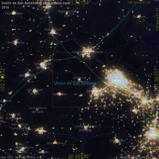
Analysis of Unión de San Antonio night lights 2016
Square area 10x10 km:
 0%
0%90-99
0.79%80-89
1.59%70-79
0.79%60-69
1.19%50-59
0.4%40-49
0%30-39
1.59%20-29
0%10-19
1.98%0-9
91.67%Square area 50x50 km:
0.44%90-99
1.15%80-89
2.07%70-79
1.44%60-69
1.16%50-59
0.89%40-49
2.09%30-39
1.83%20-29
3.65%10-19
6.57%0-9
78.71%Clear (daylight) street map image can be seen on geolist.org.
Map coordinates:
21° 46' 53.5" North, 102° 42' 33.6" West
21° 7' 37.7" North, 102° 0' 22.3" West
20° 28' 11.4" North, 101° 18' 11.1" West
Some cities around Unión de San Antonio sort by population:
• Lagos de Moreno
26.5 km =16.5 mi,  15°
15°
• San Francisco del Rincón
19.8 km =12.3 mi,  127°
127°
• Purísima de Bustos
17 km =10.6 mi, 128°
• Centro Familiar la Soledad
26.6 km =16.5 mi,  88°
88°
• La Ermita
28.5 km =17.7 mi,  84°
84°
• San Julián
22.2 km =13.8 mi,  234°
234°
• San Diego de Alejandría
14.9 km =9.3 mi,  175°
175°
• Plan de Ayala
30.1 km =18.7 mi,  101°
101°
3980799 (p: 7,620)
Sources (retrieved 2019-11-25):
» Earth at Night: Flat Maps 2012, 2016