Purísima de Bustos night lights from space
Night Light of Purísima de Bustos (Guanajuato) from space (Mexico) Src. Average luminocity for 10x10km area is 51.8829% and for 50x50km: 19.9618%.
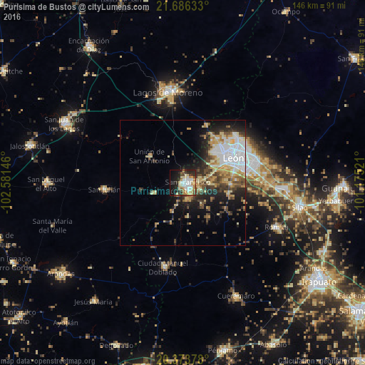

Analysis of Purísima de Bustos night lights 2016
Square area 10x10 km:
 9.33%
9.33%90-99
12.7%80-89
9.92%70-79
8.33%60-69
5.16%50-59
2.58%40-49
4.96%30-39
4.96%20-29
14.68%10-19
20.63%0-9
6.75%Square area 50x50 km:
4.41%90-99
2.92%80-89
3.21%70-79
2.61%60-69
2.36%50-59
1.68%40-49
3.53%30-39
2.62%20-29
4.87%10-19
8.15%0-9
63.64%Clear (daylight) street map image can be seen on geolist.org.
Map coordinates:
21° 41' 10.8" North, 102° 34' 53.3" West
21° 1' 53.4" North, 101° 52' 42" West
20° 22' 25.6" North, 101° 10' 30.8" West
Some cities around Purísima de Bustos sort by population:
• León de los Aldama
23.8 km =14.8 mi,  62°
62°
• San Francisco del Rincón
2.8 km =1.7 mi,  121°
121°
• Centro Familiar la Soledad
17.6 km =10.9 mi,  49°
49°
• La Ermita
20.2 km =12.6 mi, 48°
• Medina
29.6 km =18.4 mi, 63°
• Unión de San Antonio
17 km =10.6 mi,  308°
308°
• San Diego de Alejandría
12.9 km =8 mi,  250°
250°
• Plan de Ayala
16.9 km =10.5 mi,  74°
74°
3991226 (p: 43,512)
Sources (retrieved 2019-11-25):
» Earth at Night: Flat Maps 2012, 2016