San Juan Tilapa night lights from space
Night Light of San Juan Tilapa (Morelos) from space (Mexico) Src. Average luminocity for 10x10km area is 62.6948% and for 50x50km: 38.0557%.
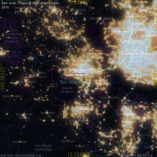
Analysis of San Juan Tilapa night lights 2016
Square area 10x10 km:
 9.09%
9.09%90-99
10.61%80-89
16.02%70-79
17.97%60-69
6.06%50-59
7.14%40-49
5.41%30-39
5.84%20-29
12.77%10-19
8.23%0-9
0.87%Square area 50x50 km:
4.26%90-99
4.26%80-89
6.97%70-79
8.11%60-69
10.56%50-59
5.04%40-49
5.44%30-39
4.81%20-29
7.77%10-19
10.74%0-9
32.04%Clear (daylight) street map image can be seen on geolist.org.
Map coordinates:
19° 52' 58" North, 100° 21' 47.7" West
19° 13' 12.8" North, 99° 39' 36.4" West
18° 33' 17.8" North, 98° 57' 25.2" West
Some cities around San Juan Tilapa sort by population:
• San Francisco Cuaxusco
6.8 km =4.2 mi,  39°
39°
• Santiago Tlacotepec
1.4 km =0.9 mi,  304°
304°
• Cacalomacan
6.1 km =3.8 mi,  307°
307°
• San Bartolomé Tlaltelulco
3.3 km =2.1 mi,  76°
76°
• San Buenaventura
5.3 km =3.3 mi,  344°
344°
• San Felipe Tlalmimilolpan
2.8 km =1.7 mi, 41°
• Santa María Magdalena Ocotitlán
4.2 km =2.6 mi,  63°
63°
• Santa María Nativitas
3.4 km =2.1 mi,  106°
106°
3827274 (p: 8,420)
Sources (retrieved 2019-11-25):
» Earth at Night: Flat Maps 2012, 2016