Santiago Tlacotepec night lights from space
Night Light of Santiago Tlacotepec (México) from space (Mexico) Src. Average luminocity for 10x10km area is 65.7532% and for 50x50km: 37.2561%.
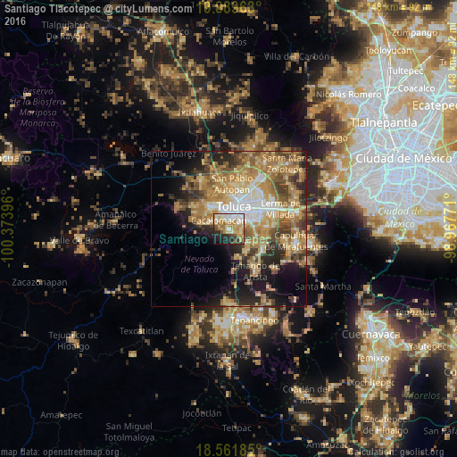
Analysis of Santiago Tlacotepec night lights 2016
Square area 10x10 km:
 12.77%
90-99
13.85%80-89
15.8%70-79
15.37%60-69
6.49%50-59
5.63%40-49
3.46%30-39
4.76%20-29
13.42%10-19
7.58%0-9
0.87%Square area 50x50 km:
4.23%90-99
4.16%80-89
6.84%70-79
7.86%60-69
10.65%50-59
4.98%40-49
5.26%30-39
4.55%20-29
7.02%10-19
10.37%0-9
34.09%Clear (daylight) street map image can be seen on geolist.org.
Map coordinates:
19° 53' 22.7" North, 100° 22' 26.3" West
19° 13' 37.5" North, 99° 40' 15" West
18° 33' 42.7" North, 98° 58' 3.8" West
Some cities around Santiago Tlacotepec sort by population:
• San Jorge Pueblo Nuevo
5.4 km =3.4 mi,  56°
56°
• Cacalomacan
4.7 km =2.9 mi,  307°
307°
• San Bartolomé Tlaltelulco
4.3 km =2.7 mi,  89°
89°
• San Buenaventura
4.3 km =2.7 mi,  356°
356°
• San Felipe Tlalmimilolpan
3.3 km =2.1 mi,  65°
65°
• San Juan Tilapa
1.4 km =0.9 mi,  124°
124°
• Santa María Magdalena Ocotitlán
5 km =3.1 mi,  77°
77°
• Santa María Nativitas
4.7 km =2.9 mi,  111°
111°
3762210 (p: 15,853)
Sources (retrieved 2019-11-25):
» Earth at Night: Flat Maps 2012, 2016