Cacalomacan night lights from space
Night Light of Cacalomacan (México) from space (Mexico) Src. Average luminocity for 10x10km area is 73.8312% and for 50x50km: 34.682%.
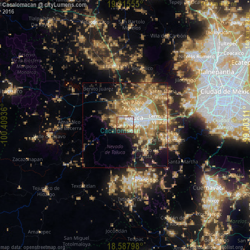
Analysis of Cacalomacan night lights 2016
Square area 10x10 km:
 17.53%
90-99
17.1%80-89
16.88%70-79
13.64%60-69
13.42%50-59
2.81%40-49
2.16%30-39
2.38%20-29
10.61%10-19
3.46%0-9
0%Square area 50x50 km:
4.13%90-99
3.98%80-89
6.03%70-79
7.34%60-69
9.73%50-59
4.9%40-49
5.19%30-39
3.87%20-29
6.15%10-19
9.87%0-9
38.81%Clear (daylight) street map image can be seen on geolist.org.
Map coordinates:
19° 54' 56" North, 100° 24' 33.7" West
19° 15' 11.2" North, 99° 42' 22.4" West
18° 35' 16.7" North, 99° 0' 11.2" West
Some cities around Cacalomacan sort by population:
• Toluca
6.8 km =4.2 mi,  55°
55°
• Zinacantepec
4.5 km =2.8 mi,  319°
319°
• Santiago Tlacotepec
4.7 km =2.9 mi,  127°
127°
• San Juan de las Huertas
5.5 km =3.4 mi,  263°
263°
• San Buenaventura
3.7 km =2.3 mi,  67°
67°
• San Juan Tilapa
6.1 km =3.8 mi, 127°
• Santa Cruz Cuauhtenco
2.5 km =1.6 mi, 259°
• San Antonio Buenavista
1 km =0.6 mi,  325°
325°
3531889 (p: 12,001)
Sources (retrieved 2019-11-25):
» Earth at Night: Flat Maps 2012, 2016