San Felipe Tlalmimilolpan night lights from space
Night Light of San Felipe Tlalmimilolpan (México) from space (Mexico) Src. Average luminocity for 10x10km area is 78.1948% and for 50x50km: 39.1394%.
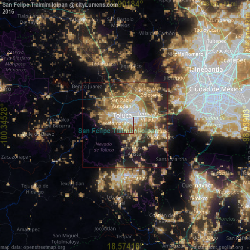
Analysis of San Felipe Tlalmimilolpan night lights 2016
Square area 10x10 km:
 25.32%
90-99
16.67%80-89
13.42%70-79
15.37%60-69
7.58%50-59
8.87%40-49
3.9%30-39
3.03%20-29
5.63%10-19
0.22%0-9
0%Square area 50x50 km:
4.27%90-99
4.27%80-89
6.95%70-79
8.18%60-69
11.11%50-59
5.12%40-49
6.07%30-39
4.97%20-29
8.85%10-19
10.93%0-9
29.29%Clear (daylight) street map image can be seen on geolist.org.
Map coordinates:
19° 54' 6.6" North, 100° 20' 43" West
19° 14' 21.6" North, 99° 38' 31.7" West
18° 34' 27" North, 98° 56' 20.5" West
Some cities around San Felipe Tlalmimilolpan sort by population:
• Metepec
4.8 km =3 mi,  62°
62°
• San Jorge Pueblo Nuevo
2.2 km =1.4 mi,  42°
42°
• Santiago Tlacotepec
3.3 km =2.1 mi,  245°
245°
• San Bartolomé Tlaltelulco
1.9 km =1.2 mi,  135°
135°
• San Buenaventura
4.4 km =2.7 mi,  312°
312°
• San Juan Tilapa
2.8 km =1.7 mi,  221°
221°
• Santa María Magdalena Ocotitlán
1.9 km =1.2 mi,  97°
97°
• Santa María Nativitas
3.4 km =2.1 mi,  156°
156°
3827262 (p: 9,512)
Sources (retrieved 2019-11-25):
» Earth at Night: Flat Maps 2012, 2016