Santa María Nativitas night lights from space
Night Light of Santa María Nativitas (México) from space (Mexico) Src. Average luminocity for 10x10km area is 65.5541% and for 50x50km: 40.0291%.
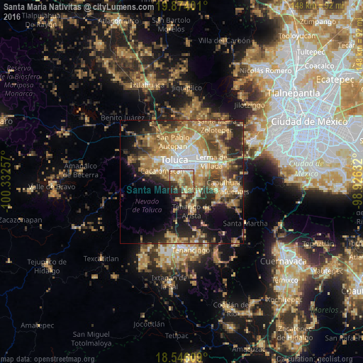
Analysis of Santa María Nativitas night lights 2016
Square area 10x10 km:
 5.84%
5.84%90-99
10.17%80-89
14.72%70-79
23.81%60-69
9.74%50-59
10.61%40-49
6.49%30-39
6.06%20-29
9.31%10-19
3.25%0-9
0%Square area 50x50 km:
4.34%90-99
4.35%80-89
7.34%70-79
8.33%60-69
11.09%50-59
5.12%40-49
5.83%30-39
5.41%20-29
9.63%10-19
11.34%0-9
27.23%Clear (daylight) street map image can be seen on geolist.org.
Map coordinates:
19° 52' 26.4" North, 100° 19' 57.3" West
19° 12' 41" North, 99° 37' 46" West
18° 32' 45.9" North, 98° 55' 34.8" West
Some cities around Santa María Nativitas sort by population:
• San Jorge Pueblo Nuevo
4.8 km =3 mi,  2°
2°
• Santiago Tlacotepec
4.7 km =2.9 mi,  291°
291°
• San Bartolomé Tlaltelulco
1.8 km =1.1 mi,  359°
359°
• Mexicaltzingo
4.7 km =2.9 mi,  90°
90°
• San Felipe Tlalmimilolpan
3.4 km =2.1 mi,  336°
336°
• San Juan Tilapa
3.4 km =2.1 mi, 286°
• San Miguel Totocuitlapilco
4.2 km =2.6 mi,  62°
62°
• San Andrés Ocotlán
5 km =3.1 mi,  114°
114°
3827276 (p: 6,258)
Sources (retrieved 2019-11-25):
» Earth at Night: Flat Maps 2012, 2016