Tlapanaloya night lights from space
Night Light of Tlapanaloya (Morelos) from space (Mexico) Src. Average luminocity for 10x10km area is 31.197% and for 50x50km: 42.0974%.
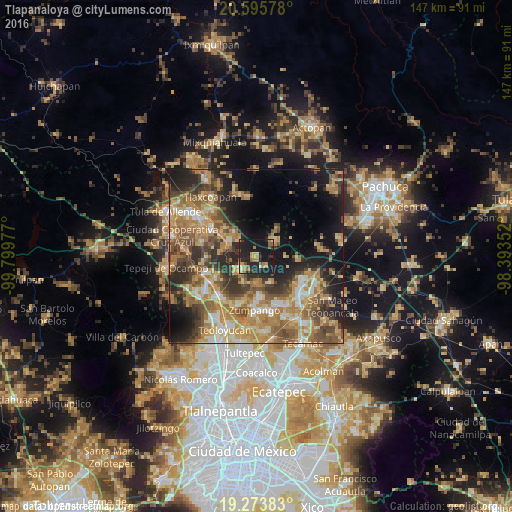
Analysis of Tlapanaloya night lights 2016
Square area 10x10 km:
 0.22%
0.22%90-99
0.87%80-89
5.19%70-79
4.98%60-69
9.74%50-59
3.03%40-49
3.9%30-39
2.16%20-29
18.83%10-19
49.35%0-9
1.73%Square area 50x50 km:
3.26%90-99
4.85%80-89
6.79%70-79
9.07%60-69
11.26%50-59
6.8%40-49
7.46%30-39
6.58%20-29
10.02%10-19
14.04%0-9
19.86%Clear (daylight) street map image can be seen on geolist.org.
Map coordinates:
20° 35' 44.8" North, 99° 47' 59.2" West
19° 56' 10.3" North, 99° 5' 47.9" West
19° 16' 25.8" North, 98° 23' 36.7" West
Some cities around Tlapanaloya sort by population:
• Tequixquiac
5.8 km =3.6 mi,  239°
239°
• Apaxco de Ocampo
8.9 km =5.5 mi,  299°
299°
• Fraccionamiento la Trinidad
12 km =7.5 mi,  173°
173°
• Santa María Ajoloapan
7.1 km =4.4 mi,  50°
50°
• Jilotzingo
8.3 km =5.2 mi,  154°
154°
• San Francisco Zacacalco
11.9 km =7.4 mi,  93°
93°
• Miguel Bocanegra
10.2 km =6.3 mi,  189°
189°
• Arbolada los Sauces
14.5 km =9 mi,  157°
157°
3515383 (p: 6,466)
Sources (retrieved 2019-11-25):
» Earth at Night: Flat Maps 2012, 2016