Jilotzingo night lights from space
Night Light of Jilotzingo (México) from space (Mexico) Src. Average luminocity for 10x10km area is 40.9372% and for 50x50km: 50.5726%.
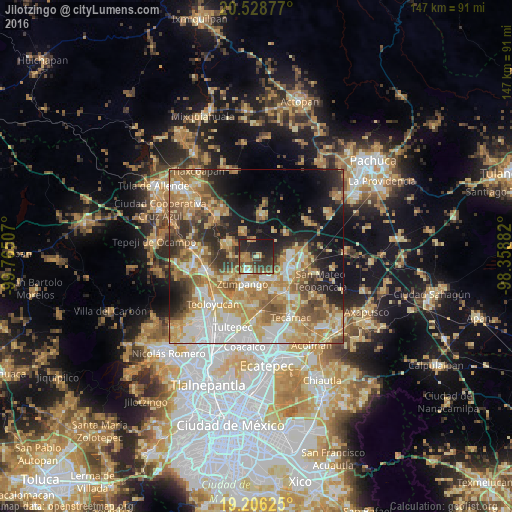
Analysis of Jilotzingo night lights 2016
Square area 10x10 km:
 2.38%
2.38%90-99
1.95%80-89
5.63%70-79
4.76%60-69
9.74%50-59
9.09%40-49
9.09%30-39
14.94%20-29
20.56%10-19
21.86%0-9
0%Square area 50x50 km:
7.55%90-99
8.14%80-89
9.06%70-79
10.29%60-69
11.2%50-59
6.62%40-49
6.32%30-39
5.26%20-29
8.32%10-19
12.79%0-9
14.45%Clear (daylight) street map image can be seen on geolist.org.
Map coordinates:
20° 31' 43.6" North, 99° 45' 54.3" West
19° 52' 8" North, 99° 3' 43" West
19° 12' 22.5" North, 98° 21' 31.8" West
Some cities around Jilotzingo sort by population:
• Zumpango
8.9 km =5.5 mi,  206°
206°
• Tizayuca
9.6 km =6 mi,  111°
111°
• San Bartolo Cuautlalpan
8 km =5 mi,  137°
137°
• Fraccionamiento la Trinidad
4.9 km =3 mi, 206°
• Tlapanaloya
8.3 km =5.2 mi,  334°
334°
• San Sebastián
9.4 km =5.8 mi,  175°
175°
• Miguel Bocanegra
5.8 km =3.6 mi,  243°
243°
• Arbolada los Sauces
6.2 km =3.9 mi,  162°
162°
3526499 (p: 8,523)
Sources (retrieved 2019-11-25):
» Earth at Night: Flat Maps 2012, 2016