San Antonio Buenavista night lights from space
Night Light of San Antonio Buenavista (México) from space (Mexico) Src. Average luminocity for 10x10km area is 76.026% and for 50x50km: 33.9381%.
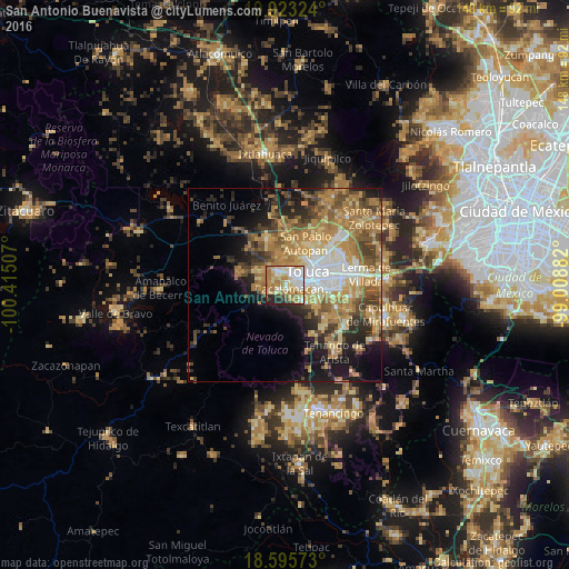
Analysis of San Antonio Buenavista night lights 2016
Square area 10x10 km:
 14.5%
14.5%90-99
18.61%80-89
18.4%70-79
14.94%60-69
17.53%50-59
2.81%40-49
2.16%30-39
2.16%20-29
7.58%10-19
1.3%0-9
0%Square area 50x50 km:
4.1%90-99
3.86%80-89
5.79%70-79
7.27%60-69
9.4%50-59
4.84%40-49
5.05%30-39
3.84%20-29
6.1%10-19
9.73%0-9
40.01%Clear (daylight) street map image can be seen on geolist.org.
Map coordinates:
19° 55' 23.7" North, 100° 24' 54.3" West
19° 15' 39" North, 99° 42' 43" West
18° 35' 44.6" North, 99° 0' 31.8" West
Some cities around San Antonio Buenavista sort by population:
• Toluca
6.9 km =4.3 mi,  63°
63°
• Zinacantepec
3.5 km =2.2 mi,  318°
318°
• Santiago Tlacotepec
5.7 km =3.5 mi,  131°
131°
• San Juan de las Huertas
5.1 km =3.2 mi,  253°
253°
• Cacalomacan
1 km =0.6 mi,  145°
145°
• San Buenaventura
4.1 km =2.5 mi,  82°
82°
• Ejido San Lorenzo Cuauhtenco
6 km =3.7 mi, 318°
• Santa Cruz Cuauhtenco
2.3 km =1.4 mi,  234°
234°
3827260 (p: 5,937)
Sources (retrieved 2019-11-25):
» Earth at Night: Flat Maps 2012, 2016