San Blas night lights from space
Night Light of San Blas (Sinaloa) from space (Mexico) Src. Average luminocity for 10x10km area is 9.0794% and for 50x50km: 1.4866%.
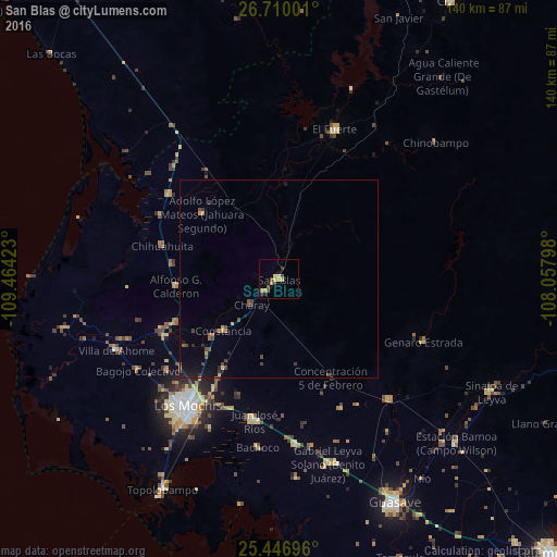
Analysis of San Blas night lights 2016
Square area 10x10 km:
 0%
0%90-99
0%80-89
2.38%70-79
3.37%60-69
0.79%50-59
1.59%40-49
2.18%30-39
0.79%20-29
1.59%10-19
0.79%0-9
86.51%Square area 50x50 km:
0%90-99
0%80-89
0.18%70-79
0.34%60-69
0.14%50-59
0.26%40-49
0.48%30-39
0.26%20-29
0.28%10-19
0.86%0-9
97.2%Clear (daylight) street map image can be seen on geolist.org.
Map coordinates:
26° 42' 36" North, 109° 27' 51.2" West
26° 4' 48.7" North, 108° 45' 40" West
25° 26' 49.1" North, 108° 3' 28.7" West
Some cities around San Blas sort by population:
• Los Mochis
39.8 km =24.7 mi,  216°
216°
• Juan José Ríos
36.4 km =22.6 mi,  189°
189°
• Adolfo Ruíz Cortínes
36.7 km =22.8 mi,  178°
178°
• El Fuerte
40.1 km =24.9 mi,  20°
20°
• Constancia
19.1 km =11.9 mi,  226°
226°
• Naranjo
41.4 km =25.7 mi,  137°
137°
• San Miguel Zapotitlan
32.1 km =19.9 mi,  242°
242°
• Mochicahui
22.2 km =13.8 mi, 229°
3987538 (p: 6,075)
Sources (retrieved 2019-11-25):
» Earth at Night: Flat Maps 2012, 2016