Naranjo night lights from space
Night Light of Naranjo (Sinaloa) from space (Mexico) Src. Average luminocity for 10x10km area is 3.4792% and for 50x50km: 3.2029%.
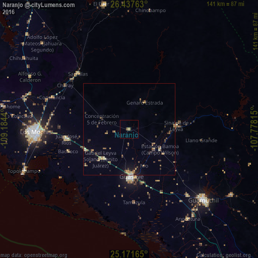
Analysis of Naranjo night lights 2016
Square area 10x10 km:
 0%
0%90-99
0%80-89
0%70-79
1.52%60-69
1.52%50-59
0.19%40-49
1.33%30-39
0%20-29
0%10-19
0.76%0-9
94.7%Square area 50x50 km:
0.05%90-99
0.14%80-89
0.61%70-79
0.68%60-69
0.29%50-59
0.64%40-49
0.72%30-39
0.56%20-29
0.45%10-19
1.19%0-9
94.68%Clear (daylight) street map image can be seen on geolist.org.
Map coordinates:
26° 26' 15.5" North, 109° 11' 3.8" West
25° 48' 22.8" North, 108° 28' 52.6" West
25° 10' 17.9" North, 107° 46' 41.3" West
Some cities around Naranjo sort by population:
• Guasave
26.6 km =16.5 mi,  177°
177°
• Leyva Solano
22.4 km =13.9 mi,  224°
224°
• Juan José Ríos
34.8 km =21.6 mi,  261°
261°
• Adolfo Ruiz Cortines
26.5 km =16.5 mi,  244°
244°
• Adolfo Ruíz Cortínes
27.6 km =17.1 mi, 256°
• Estacion Bamoa
20.1 km =12.5 mi,  122°
122°
• San Blas
41.4 km =25.7 mi,  317°
317°
• Sinaloa de Leyva
25.9 km =16.1 mi,  86°
86°
3995093 (p: 6,307)
Sources (retrieved 2019-11-25):
» Earth at Night: Flat Maps 2012, 2016