San Miguel Zapotitlan night lights from space
Night Light of San Miguel Zapotitlan (Sinaloa) from space (Mexico) Src. Average luminocity for 10x10km area is 12.2798% and for 50x50km: 8.1326%.
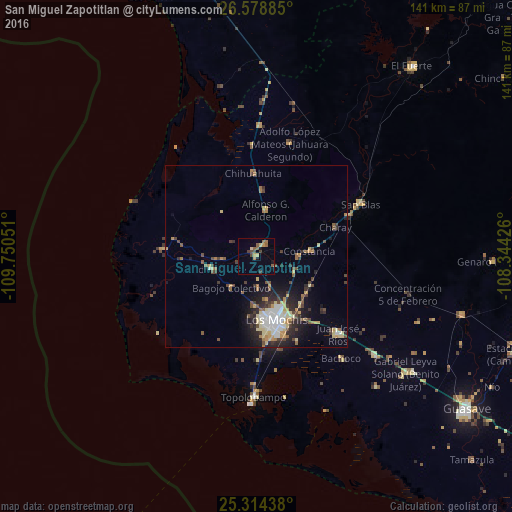
Analysis of San Miguel Zapotitlan night lights 2016
Square area 10x10 km:
 0%
0%90-99
0%80-89
2.58%70-79
1.39%60-69
2.78%50-59
3.57%40-49
2.78%30-39
1.98%20-29
0.4%10-19
2.18%0-9
82.34%Square area 50x50 km:
0.93%90-99
1.06%80-89
1.42%70-79
1.14%60-69
0.94%50-59
0.93%40-49
1.57%30-39
0.95%20-29
2.27%10-19
3.63%0-9
85.16%Clear (daylight) street map image can be seen on geolist.org.
Map coordinates:
26° 34' 43.9" North, 109° 45' 1.8" West
25° 56' 53.9" North, 109° 2' 50.6" West
25° 18' 51.8" North, 108° 20' 39.3" West
Some cities around San Miguel Zapotitlan sort by population:
• Los Mochis
18 km =11.2 mi,  164°
164°
• Juan José Ríos
30.8 km =19.1 mi,  133°
133°
• Adolfo Ruíz Cortínes
37 km =23 mi, 126°
• Ahome
13 km =8.1 mi,  255°
255°
• Higuera de Zaragoza
25.8 km =16 mi,  275°
275°
• Constancia
14.9 km =9.3 mi,  84°
84°
• San Blas
32.1 km =19.9 mi,  62°
62°
• Mochicahui
11.7 km =7.3 mi,  88°
88°
3985301 (p: 6,048)
Sources (retrieved 2019-11-25):
» Earth at Night: Flat Maps 2012, 2016