El Fuerte night lights from space
Night Light of El Fuerte (Sinaloa) from space (Mexico) Src. Average luminocity for 10x10km area is 8.5549% and for 50x50km: 0.5248%.
Analysis of El Fuerte night lights 2016
Square area 10x10 km:
 0.57%
0.57%90-99
0.19%80-89
2.84%70-79
2.46%60-69
0%50-59
0.76%40-49
2.27%30-39
0.76%20-29
0.76%10-19
0.76%0-9
88.64%Square area 50x50 km:
0.02%90-99
0.02%80-89
0.14%70-79
0.1%60-69
0.02%50-59
0.06%40-49
0.19%30-39
0.09%20-29
0.07%10-19
0.17%0-9
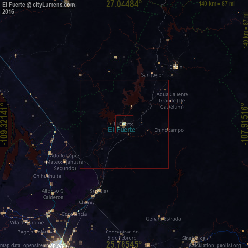
99.12%Clear (daylight) street map image can be seen on geolist.org.
Map coordinates:
27° 2' 41.4" North, 109° 19' 17.1" West
26° 25' 0.7" North, 108° 37' 5.8" West
25° 47' 7.6" North, 107° 54' 54.6" West
Some cities around El Fuerte sort by population:
• Adolfo Ruíz Cortínes
75.3 km =46.8 mi,  190°
190°
• Álamos
74.4 km =46.2 mi,  335°
335°
• Choix
43.6 km =27.1 mi,  41°
41°
• Constancia
57.8 km =35.9 mi,  209°
209°
• Naranjo
69.2 km =43 mi,  168°
168°
• San Blas
40.1 km =24.9 mi,  200°
200°
• San Miguel Zapotitlan
67.4 km =41.9 mi,  219°
219°
• Mochicahui
60.4 km =37.5 mi, 210°
4009788 (p: 12,566)
Sources (retrieved 2019-11-25):
» Earth at Night: Flat Maps 2012, 2016