Adolfo Ruíz Cortínes night lights from space
Night Light of Adolfo Ruíz Cortínes (Sinaloa) from space (Mexico) Src. Average luminocity for 10x10km area is 6.1534% and for 50x50km: 6.1362%.
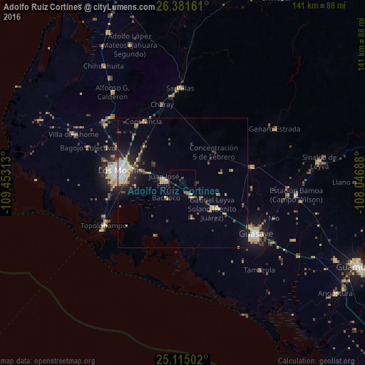
Analysis of Adolfo Ruíz Cortínes night lights 2016
Square area 10x10 km:
 0%
0%90-99
0.38%80-89
1.14%70-79
0%60-69
0%50-59
1.89%40-49
1.7%30-39
2.46%20-29
0.76%10-19
0.19%0-9
91.48%Square area 50x50 km:
0.59%90-99
0.69%80-89
1.06%70-79
1.03%60-69
0.44%50-59
0.6%40-49
1.24%30-39
0.82%20-29
1.62%10-19
2.87%0-9
89.04%Clear (daylight) street map image can be seen on geolist.org.
Map coordinates:
26° 22' 53.8" North, 109° 27' 11.3" West
25° 45' 0" North, 108° 45' 0" West
25° 6' 54.1" North, 108° 2' 48.8" West
Some cities around Adolfo Ruíz Cortínes sort by population:
• Los Mochis
25.3 km =15.7 mi,  280°
280°
• Guasave
34.8 km =21.6 mi,  125°
125°
• Leyva Solano
15 km =9.3 mi, 130°
• Juan José Ríos
7.5 km =4.7 mi, 276°
• Constancia
27.9 km =17.3 mi,  327°
327°
• Topolobampo
34.5 km =21.4 mi,  241°
241°
• Naranjo
27.6 km =17.1 mi,  76°
76°
• Mochicahui
28.7 km =17.8 mi,  321°
321°
4019727 (p: 12,947)
Sources (retrieved 2019-11-25):
» Earth at Night: Flat Maps 2012, 2016