San Bartolo night lights from space
Night Light of San Bartolo (México) from space (Mexico) Src. Average luminocity for 10x10km area is 89.8058% and for 50x50km: 66.9306%.
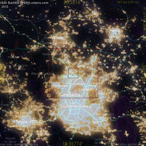
Analysis of San Bartolo night lights 2016
Square area 10x10 km:
 27.89%
90-99
30.17%80-89
17.56%70-79
20.25%60-69
3.72%50-59
0.41%40-49
0%30-39
0%20-29
0%10-19
0%0-9
0%Square area 50x50 km:
19.87%90-99
12.39%80-89
11.14%70-79
11.59%60-69
10.23%50-59
5.88%40-49
5.27%30-39
5.1%20-29
7.52%10-19
6.98%0-9
4.02%Clear (daylight) street map image can be seen on geolist.org.
Map coordinates:
20° 23' 29" North, 99° 51' 46.3" West
19° 43' 51.4" North, 99° 9' 35" West
19° 4' 3.9" North, 98° 27' 23.8" West
Some cities around San Bartolo sort by population:
• Cuautitlán
7 km =4.3 mi,  197°
197°
• Tultepec
6.1 km =3.8 mi,  147°
147°
• Teoloyucan
2.7 km =1.7 mi,  303°
303°
• Melchor Ocampo
3.6 km =2.2 mi, 154°
• Tepotzotlán
6.8 km =4.2 mi,  260°
260°
• Coyotepec
7.6 km =4.7 mi,  312°
312°
• Jaltenco
7.3 km =4.5 mi,  70°
70°
• San Mateo Ixtacalco
3.7 km =2.3 mi, 199°
3827582 (p: 6,404)
Sources (retrieved 2019-11-25):
» Earth at Night: Flat Maps 2012, 2016