Jaltenco night lights from space
Night Light of Jaltenco (México) from space (Mexico) Src. Average luminocity for 10x10km area is 77.4897% and for 50x50km: 67.2985%.
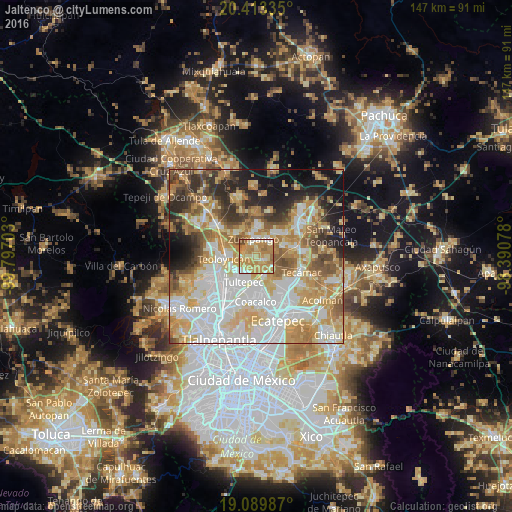
Analysis of Jaltenco night lights 2016
Square area 10x10 km:
 6.2%
6.2%90-99
13.02%80-89
16.32%70-79
38.84%60-69
20.66%50-59
3.1%40-49
1.86%30-39
0%20-29
0%10-19
0%0-9
0%Square area 50x50 km:
18.37%90-99
13.02%80-89
12.12%70-79
12.16%60-69
9.71%50-59
6.25%40-49
5.53%30-39
4.98%20-29
7.43%10-19
8.36%0-9
2.07%Clear (daylight) street map image can be seen on geolist.org.
Map coordinates:
20° 24' 48.1" North, 99° 47' 49.3" West
19° 45' 10.7" North, 99° 5' 38" West
19° 5' 23.5" North, 98° 23' 26.8" West
Some cities around Jaltenco sort by population:
• Tultepec
8.4 km =5.2 mi,  205°
205°
• Zumpango
4.9 km =3 mi,  353°
353°
• Melchor Ocampo
7.8 km =4.8 mi,  223°
223°
• Santa Ana Nextlalpan
2.3 km =1.4 mi,  122°
122°
• Tonanitla
8.4 km =5.2 mi,  149°
149°
• San Bartolo
7.3 km =4.5 mi,  250°
250°
• San Sebastián
5.3 km =3.3 mi,  49°
49°
• Ex-Hacienda Santa Inés
5.6 km =3.5 mi,  156°
156°
3526600 (p: 11,093)
Sources (retrieved 2019-11-25):
» Earth at Night: Flat Maps 2012, 2016