Ejido San Lorenzo Cuauhtenco night lights from space
Night Light of Ejido San Lorenzo Cuauhtenco (México) from space (Mexico) Src. Average luminocity for 10x10km area is 64.9805% and for 50x50km: 30.6768%.
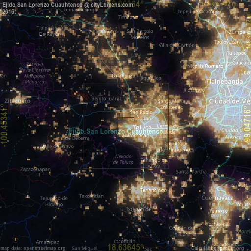
Analysis of Ejido San Lorenzo Cuauhtenco night lights 2016
Square area 10x10 km:
 2.81%
2.81%90-99
6.93%80-89
12.12%70-79
18.18%60-69
31.17%50-59
7.79%40-49
6.28%30-39
9.52%20-29
5.19%10-19
0%0-9
0%Square area 50x50 km:
3.95%90-99
3.67%80-89
5.06%70-79
6.47%60-69
8.13%50-59
4.15%40-49
4.15%30-39
3.44%20-29
6.21%10-19
9.36%0-9
45.4%Clear (daylight) street map image can be seen on geolist.org.
Map coordinates:
19° 57' 49.1" North, 100° 27' 12.3" West
19° 18' 5" North, 99° 45' 1" West
18° 38' 11.2" North, 99° 2' 49.8" West
Some cities around Ejido San Lorenzo Cuauhtenco sort by population:
• Zinacantepec
2.6 km =1.6 mi,  137°
137°
• San Francisco Tlalcilalcalpan
2 km =1.2 mi,  247°
247°
• San Antonio Acahualco
3.8 km =2.4 mi,  216°
216°
• San Juan de las Huertas
6 km =3.7 mi,  188°
188°
• Santiaguito Tlalcilalcalli
5 km =3.1 mi,  29°
29°
• La Cabecera
6.1 km =3.8 mi,  2°
2°
• Conjunto Urbano la Loma I
3.4 km =2.1 mi, 34°
• San Antonio Buenavista
6 km =3.7 mi, 138°
8858186 (p: 8,024)
Sources (retrieved 2019-11-25):
» Earth at Night: Flat Maps 2012, 2016