Santa Cruz Cuauhtenco night lights from space
Night Light of Santa Cruz Cuauhtenco (México) from space (Mexico) Src. Average luminocity for 10x10km area is 60.6948% and for 50x50km: 32.1103%.
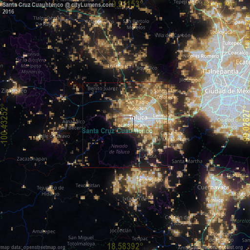
Analysis of Santa Cruz Cuauhtenco night lights 2016
Square area 10x10 km:
 5.84%
5.84%90-99
9.09%80-89
14.72%70-79
13.64%60-69
21.43%50-59
4.11%40-49
3.03%30-39
3.03%20-29
13.42%10-19
11.04%0-9
0.65%Square area 50x50 km:
4.07%90-99
3.73%80-89
5.46%70-79
6.71%60-69
8.64%50-59
4.43%40-49
4.57%30-39
3.68%20-29
6.21%10-19
9.5%0-9
43%Clear (daylight) street map image can be seen on geolist.org.
Map coordinates:
19° 54' 41.5" North, 100° 25' 57.1" West
19° 14' 56.7" North, 99° 43' 45.8" West
18° 35' 2.1" North, 99° 1' 34.6" West
Some cities around Santa Cruz Cuauhtenco sort by population:
• Zinacantepec
3.9 km =2.4 mi,  353°
353°
• San Francisco Tlalcilalcalpan
6.5 km =4 mi,  321°
321°
• San Antonio Acahualco
5.2 km =3.2 mi,  301°
301°
• San Juan de las Huertas
3 km =1.9 mi,  266°
266°
• Cacalomacan
2.5 km =1.6 mi,  79°
79°
• San Buenaventura
6.2 km =3.9 mi,  72°
72°
• Ejido San Lorenzo Cuauhtenco
6.2 km =3.9 mi,  339°
339°
• San Antonio Buenavista
2.3 km =1.4 mi,  54°
54°
3517543 (p: 7,460)
Sources (retrieved 2019-11-25):
» Earth at Night: Flat Maps 2012, 2016