Salinas de Hidalgo night lights from space
Night Light of Salinas de Hidalgo (San Luis Potosí) from space (Mexico) Src. Average luminocity for 10x10km area is 9.6098% and for 50x50km: 1.1828%.
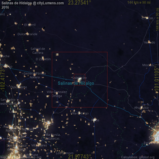
Analysis of Salinas de Hidalgo night lights 2016
Square area 10x10 km:
 1.14%
1.14%90-99
0.76%80-89
1.14%70-79
1.89%60-69
2.08%50-59
0.57%40-49
2.08%30-39
1.14%20-29
1.33%10-19
0%0-9
87.88%Square area 50x50 km:
0.05%90-99
0.09%80-89
0.15%70-79
0.22%60-69
0.11%50-59
0.23%40-49
0.42%30-39
0.33%20-29
0.22%10-19
0.09%0-9
98.1%Clear (daylight) street map image can be seen on geolist.org.
Map coordinates:
23° 16' 31.5" North, 102° 25' 2.3" West
22° 37' 40.6" North, 101° 42' 51" West
21° 58' 38.7" North, 101° 0' 39.8" West
Some cities around Salinas de Hidalgo sort by population:
• Loreto
48.6 km =30.2 mi,  215°
215°
• Trancoso
68 km =42.3 mi,  280°
280°
• Villa García
57.5 km =35.7 mi,  205°
205°
• Luis Moya
59 km =36.7 mi,  248°
248°
• Villa González Ortega
24.4 km =15.2 mi,  238°
238°
• Dulce Grande
62.8 km =39 mi,  311°
311°
• Los Zacatones
51 km =31.7 mi,  316°
316°
• Pinos
39.6 km =24.6 mi,  158°
158°
3988169 (p: 16,821)
Sources (retrieved 2019-11-25):
» Earth at Night: Flat Maps 2012, 2016