Villa González Ortega night lights from space
Night Light of Villa González Ortega (Zacatecas) from space (Mexico) Src. Average luminocity for 10x10km area is 2.7803% and for 50x50km: 3.5115%.
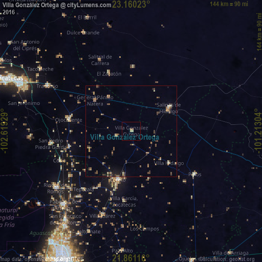
Analysis of Villa González Ortega night lights 2016
Square area 10x10 km:
 0%
0%90-99
0%80-89
0.76%70-79
1.52%60-69
0.19%50-59
0.57%40-49
0%30-39
0%20-29
0%10-19
0%0-9
96.97%Square area 50x50 km:
0.05%90-99
0.16%80-89
0.45%70-79
0.74%60-69
0.46%50-59
0.59%40-49
1.02%30-39
0.89%20-29
0.71%10-19
1.03%0-9
93.91%Clear (daylight) street map image can be seen on geolist.org.
Map coordinates:
23° 9' 36.8" North, 102° 37' 9.4" West
22° 30' 44" North, 101° 54' 58.2" West
21° 51' 40.2" North, 101° 12' 46.9" West
Some cities around Villa González Ortega sort by population:
• Rincón de Romos
52.3 km =32.5 mi,  232°
232°
• Loreto
27.7 km =17.2 mi,  195°
195°
• Salinas de Hidalgo
24.4 km =15.2 mi,  58°
58°
• Trancoso
52.5 km =32.6 mi,  298°
298°
• San Pedro Piedra Gorda
45 km =28 mi,  260°
260°
• Luis Moya
35.3 km =21.9 mi, 255°
• Los Zacatones
51.9 km =32.2 mi,  344°
344°
• Pinos
42.5 km =26.4 mi,  124°
124°
3980175 (p: 6,181)
Sources (retrieved 2019-11-25):
» Earth at Night: Flat Maps 2012, 2016