Luis Moya night lights from space
Night Light of Luis Moya (Zacatecas) from space (Mexico) Src. Average luminocity for 10x10km area is 13.8731% and for 50x50km: 7.5955%.
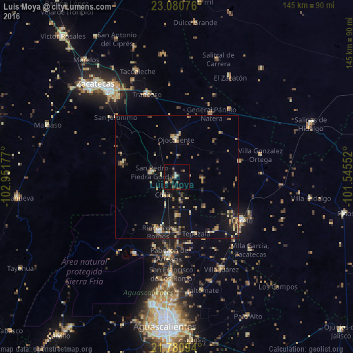
Analysis of Luis Moya night lights 2016
Square area 10x10 km:
 0.57%
0.57%90-99
1.14%80-89
2.84%70-79
1.33%60-69
2.08%50-59
2.46%40-49
1.7%30-39
1.14%20-29
1.52%10-19
6.25%0-9
78.98%Square area 50x50 km:
0.17%90-99
0.71%80-89
1.44%70-79
1.07%60-69
0.89%50-59
0.87%40-49
1.63%30-39
1.15%20-29
1.45%10-19
4.94%0-9
85.67%Clear (daylight) street map image can be seen on geolist.org.
Map coordinates:
23° 4' 50.7" North, 102° 57' 6.4" West
22° 25' 56.5" North, 102° 14' 55.1" West
21° 46' 51.4" North, 101° 32' 43.9" West
Some cities around Luis Moya sort by population:
• Pabellón de Arteaga
31.9 km =19.8 mi,  185°
185°
• Rincón de Romos
23.9 km =14.9 mi,  198°
198°
• Loreto
32.1 km =19.9 mi,  123°
123°
• San Francisco de los Romo
39.5 km =24.5 mi,  183°
183°
• Trancoso
35.8 km =22.2 mi,  340°
340°
• San Pedro Piedra Gorda
10.4 km =6.5 mi,  279°
279°
• Villa García
42.6 km =26.5 mi,  134°
134°
• Villa González Ortega
35.3 km =21.9 mi,  75°
75°
3997017 (p: 6,335)
Sources (retrieved 2019-11-25):
» Earth at Night: Flat Maps 2012, 2016