Trancoso night lights from space
Night Light of Trancoso (Zacatecas) from space (Mexico) Src. Average luminocity for 10x10km area is 12.5476% and for 50x50km: 8.541%.
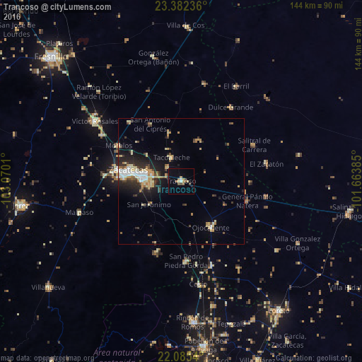
Analysis of Trancoso night lights 2016
Square area 10x10 km:
 0.6%
0.6%90-99
0.99%80-89
1.98%70-79
1.79%60-69
2.38%50-59
1.79%40-49
2.58%30-39
0.6%20-29
0.79%10-19
2.58%0-9
83.93%Square area 50x50 km:
0.93%90-99
1.18%80-89
1.58%70-79
1.37%60-69
0.85%50-59
0.55%40-49
1.23%30-39
1.23%20-29
2.59%10-19
4.66%0-9
83.83%Clear (daylight) street map image can be seen on geolist.org.
Map coordinates:
23° 22' 56.5" North, 103° 4' 12.4" West
22° 44' 7.5" North, 102° 22' 1.1" West
22° 5' 7.4" North, 101° 39' 49.9" West
Some cities around Trancoso sort by population:
• Zacatecas
22.3 km =13.9 mi,  279°
279°
• Guadalupe
15.6 km =9.7 mi,  274°
274°
• Tacoaleche
10.2 km =6.3 mi,  337°
337°
• San Pedro Piedra Gorda
32.1 km =19.9 mi,  176°
176°
• Morelos
28.7 km =17.8 mi,  299°
299°
• Luis Moya
35.8 km =22.2 mi,  160°
160°
• Dulce Grande
35.6 km =22.1 mi,  33°
33°
• Pozos de Gamboa
31.5 km =19.6 mi,  318°
318°
3981145 (p: 14,021)
Sources (retrieved 2019-11-25):
» Earth at Night: Flat Maps 2012, 2016