Pinos night lights from space
Night Light of Pinos (Zacatecas) from space (Mexico) Src. Average luminocity for 10x10km area is 7.3182% and for 50x50km: 1.4373%.
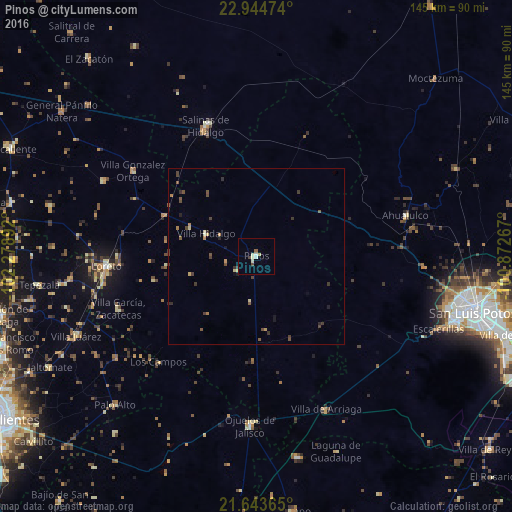
Analysis of Pinos night lights 2016
Square area 10x10 km:
 0.76%
0.76%90-99
2.08%80-89
1.14%70-79
0.95%60-69
0.19%50-59
0.57%40-49
1.33%30-39
0.57%20-29
0%10-19
0.19%0-9
92.23%Square area 50x50 km:
0.03%90-99
0.11%80-89
0.22%70-79
0.23%60-69
0.12%50-59
0.3%40-49
0.46%30-39
0.45%20-29
0.23%10-19
0.16%0-9
97.69%Clear (daylight) street map image can be seen on geolist.org.
Map coordinates:
22° 56' 41.1" North, 102° 16' 44.1" West
22° 17' 44.6" North, 101° 34' 32.8" West
21° 38' 37.1" North, 100° 52' 21.6" West
Some cities around Pinos sort by population:
• San Luis Potosí
63.5 km =39.5 mi,  104°
104°
• Loreto
42.6 km =26.5 mi,  266°
266°
• Salinas de Hidalgo
39.6 km =24.6 mi,  338°
338°
• Ojuelos de Jalisco
47.8 km =29.7 mi,  182°
182°
• Villa García
41.8 km =26 mi,  249°
249°
• Villa González Ortega
42.5 km =26.4 mi,  304°
304°
• Villa de Arriaga
47.4 km =29.5 mi,  155°
155°
• Palo Alto
58 km =36 mi,  223°
223°
3992485 (p: 5,611)
Sources (retrieved 2019-11-25):
» Earth at Night: Flat Maps 2012, 2016