Cuajinicuilapa night lights from space
Night Light of Cuajinicuilapa (Guerrero) from space (Mexico) Src. Average luminocity for 10x10km area is 7.314% and for 50x50km: 1.5754%.
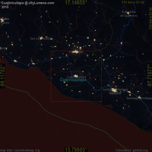
Analysis of Cuajinicuilapa night lights 2016
Square area 10x10 km:
 0%
0%90-99
1.03%80-89
2.27%70-79
0%60-69
1.65%50-59
1.65%40-49
1.24%30-39
1.24%20-29
0.83%10-19
0%0-9
90.08%Square area 50x50 km:
0%90-99
0.12%80-89
0.36%70-79
0.23%60-69
0.29%50-59
0.21%40-49
0.42%30-39
0.24%20-29
0.45%10-19
0.22%0-9
97.46%Clear (daylight) street map image can be seen on geolist.org.
Map coordinates:
17° 8' 47.6" North, 99° 7' 1.3" West
16° 28' 24.5" North, 98° 24' 50" West
15° 47' 53" North, 97° 42' 38.8" West
Some cities around Cuajinicuilapa sort by population:
• Pinotepa Nacional
41.3 km =25.7 mi,  111°
111°
• Ometepec
24.1 km =15 mi,  1°
1°
• Jamiltepec
66.4 km =41.3 mi, 108°
• San Luis Acatlán
50.5 km =31.4 mi,  317°
317°
• Copala
62 km =38.5 mi,  283°
283°
• Marquelia
44.7 km =27.8 mi,  285°
285°
• Pinotepa de Don Luis
46.9 km =29.1 mi,  96°
96°
• San Juan Colorado
49 km =30.4 mi,  91°
91°
3530046 (p: 10,282)
Sources (retrieved 2019-11-25):
» Earth at Night: Flat Maps 2012, 2016