San Juan Colorado night lights from space
Night Light of San Juan Colorado (Oaxaca) from space (Mexico) Src. Average luminocity for 10x10km area is 2.7872% and for 50x50km: 1.8266%.
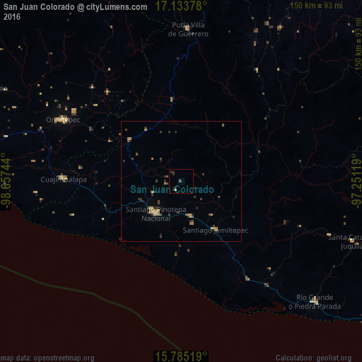
Analysis of San Juan Colorado night lights 2016
Square area 10x10 km:
 0%
0%90-99
0%80-89
0.83%70-79
0%60-69
0%50-59
0.83%40-49
0%30-39
1.65%20-29
1.65%10-19
1.65%0-9
93.39%Square area 50x50 km:
0%90-99
0.06%80-89
0.21%70-79
0.46%60-69
0.29%50-59
0.28%40-49
0.39%30-39
0.64%20-29
0.43%10-19
0.36%0-9
96.88%Clear (daylight) street map image can be seen on geolist.org.
Map coordinates:
17° 8' 1.6" North, 98° 39' 26.8" West
16° 27' 38.4" North, 97° 57' 15.5" West
15° 47' 6.7" North, 97° 15' 4.3" West
Some cities around San Juan Colorado sort by population:
• Pinotepa Nacional
17 km =10.6 mi,  218°
218°
• Ometepec
54.7 km =34 mi,  297°
297°
• Río Grande
74.6 km =46.4 mi,  132°
132°
• Putla Villa de Guerrero
63 km =39.1 mi,  2°
2°
• Cuajinicuilapa
49 km =30.4 mi,  271°
271°
• Jamiltepec
24.2 km =15 mi,  145°
145°
• Pinotepa de Don Luis
4.4 km =2.7 mi,  212°
212°
• San Miguel Panixtlahuaca
65.5 km =40.7 mi,  109°
109°
3800348 (p: 5,561)
Sources (retrieved 2019-11-25):
» Earth at Night: Flat Maps 2012, 2016