Pichucalco night lights from space
Night Light of Pichucalco (Chiapas) from space (Mexico) Src. Average luminocity for 10x10km area is 5.9897% and for 50x50km: 2.3981%.
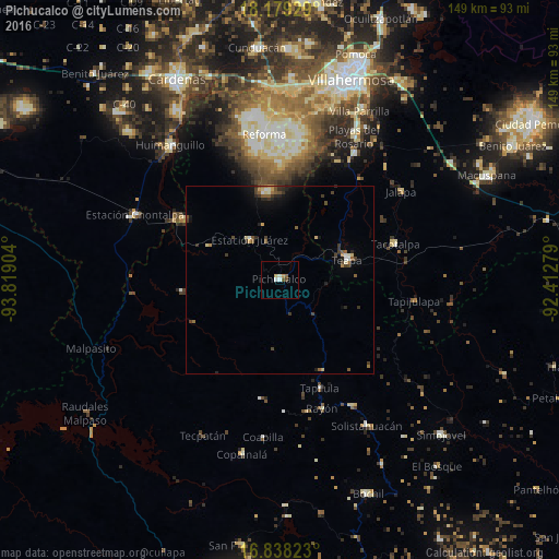
Analysis of Pichucalco night lights 2016
Square area 10x10 km:
 0.62%
0.62%90-99
1.86%80-89
0.62%70-79
1.03%60-69
0.62%50-59
1.03%40-49
0.83%30-39
0%20-29
0%10-19
0%0-9
93.39%Square area 50x50 km:
0.1%90-99
0.3%80-89
0.29%70-79
0.26%60-69
0.19%50-59
0.54%40-49
0.49%30-39
0.63%20-29
0.54%10-19
0.96%0-9
95.7%Clear (daylight) street map image can be seen on geolist.org.
Map coordinates:
18° 10' 45.4" North, 93° 49' 8.5" West
17° 30' 36" North, 93° 6' 57.3" West
16° 50' 17.6" North, 92° 24' 46" West
Some cities around Pichucalco sort by population:
• Teapa
17.9 km =11.1 mi,  75°
75°
• Río de Teapa
38 km =23.6 mi,  36°
36°
• Reforma
39.6 km =24.6 mi,  354°
354°
• Tacotalpa
32.2 km =20 mi,  72°
72°
• Tapilula
30.8 km =19.1 mi,  160°
160°
• Juárez
13.5 km =8.4 mi,  322°
322°
• Rayón
36.1 km =22.4 mi, 162°
• Rincón Chamula
38.5 km =23.9 mi,  150°
150°
3521574 (p: 14,212)
Sources (retrieved 2019-11-25):
» Earth at Night: Flat Maps 2012, 2016