Tapilula night lights from space
Night Light of Tapilula (Chiapas) from space (Mexico) Src. Average luminocity for 10x10km area is 5.4917% and for 50x50km: 2.0364%.
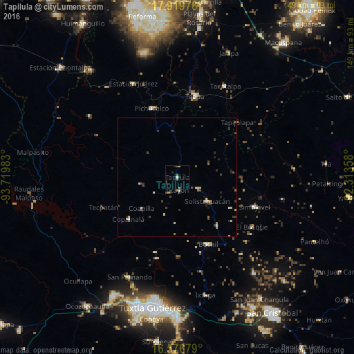
Analysis of Tapilula night lights 2016
Square area 10x10 km:
 0.41%
0.41%90-99
0.41%80-89
0.21%70-79
0.62%60-69
0%50-59
2.48%40-49
1.65%30-39
0.83%20-29
2.27%10-19
1.03%0-9
90.08%Square area 50x50 km:
0.06%90-99
0.32%80-89
0.32%70-79
0.13%60-69
0.29%50-59
0.28%40-49
0.55%30-39
0.52%20-29
0.51%10-19
0.24%0-9
96.78%Clear (daylight) street map image can be seen on geolist.org.
Map coordinates:
17° 55' 11.1" North, 93° 43' 11.4" West
17° 14' 58.2" North, 93° 1' 0.1" West
16° 34' 36.4" North, 92° 18' 48.9" West
Some cities around Tapilula sort by population:
• Teapa
34.1 km =21.2 mi,  11°
11°
• Pichucalco
30.8 km =19.1 mi,  340°
340°
• Bochil
31.1 km =19.3 mi,  154°
154°
• Simojovel de Allende
34.4 km =21.4 mi,  110°
110°
• Pueblo Nuevo
15.9 km =9.9 mi,  128°
128°
• Copainalá
26.9 km =16.7 mi,  229°
229°
• Rayón
5.4 km =3.4 mi,  173°
173°
• Rincón Chamula
9.5 km =5.9 mi,  119°
119°
3516252 (p: 7,441)
Sources (retrieved 2019-11-25):
» Earth at Night: Flat Maps 2012, 2016