Rayón night lights from space
Night Light of Rayón (Chiapas) from space (Mexico) Src. Average luminocity for 10x10km area is 5.2107% and for 50x50km: 2.4332%.
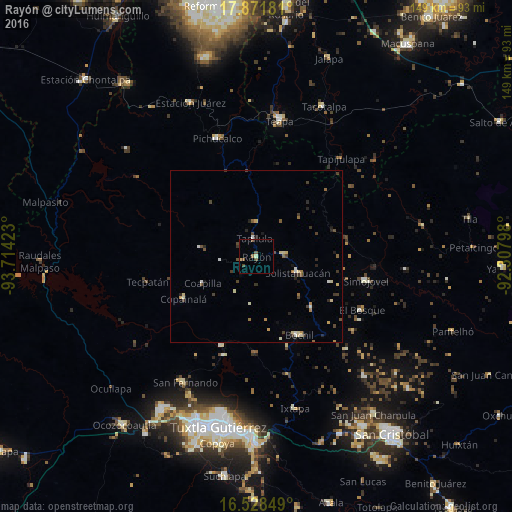
Analysis of Rayón night lights 2016
Square area 10x10 km:
 0%
0%90-99
0.83%80-89
0.83%70-79
0%60-69
0.83%50-59
2.48%40-49
1.65%30-39
0%20-29
0%10-19
0%0-9
93.39%Square area 50x50 km:
0.07%90-99
0.43%80-89
0.41%70-79
0.24%60-69
0.31%50-59
0.24%40-49
0.59%30-39
0.48%20-29
0.54%10-19
0.26%0-9
96.42%Clear (daylight) street map image can be seen on geolist.org.
Map coordinates:
17° 52' 18.5" North, 93° 42' 51.2" West
17° 12' 4.9" North, 93° 0' 40" West
16° 31' 42.6" North, 92° 18' 28.7" West
Some cities around Rayón sort by population:
• Pichucalco
36.1 km =22.4 mi,  342°
342°
• Bochil
26.1 km =16.2 mi,  151°
151°
• Simojovel de Allende
32.3 km =20.1 mi,  102°
102°
• Pueblo Nuevo
12.7 km =7.9 mi,  111°
111°
• Tapilula
5.4 km =3.4 mi,  353°
353°
• Copainalá
24.3 km =15.1 mi,  240°
240°
• Rincón Chamula
7.7 km =4.8 mi,  85°
85°
• El Bosque
34.4 km =21.4 mi,  116°
116°
3520428 (p: 5,895)
Sources (retrieved 2019-11-25):
» Earth at Night: Flat Maps 2012, 2016