Juárez night lights from space
Night Light of Juárez (Chiapas) from space (Mexico) Src. Average luminocity for 10x10km area is 6.3822% and for 50x50km: 8.0638%.
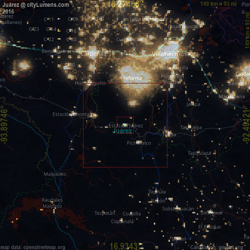
Analysis of Juárez night lights 2016
Square area 10x10 km:
 0%
0%90-99
0.83%80-89
1.03%70-79
1.45%60-69
0%50-59
2.07%40-49
1.65%30-39
1.24%20-29
1.24%10-19
0.41%0-9
90.08%Square area 50x50 km:
0.22%90-99
1.15%80-89
1.49%70-79
0.57%60-69
1.23%50-59
1.61%40-49
2.41%30-39
2.18%20-29
2.09%10-19
3.12%0-9
83.93%Clear (daylight) street map image can be seen on geolist.org.
Map coordinates:
18° 16' 28.7" North, 93° 53' 50.9" West
17° 36' 20.6" North, 93° 11' 39.6" West
16° 56' 3.5" North, 92° 29' 28.4" West
Some cities around Juárez sort by population:
• Huimanguillo
32.7 km =20.3 mi,  320°
320°
• Teapa
26.4 km =16.4 mi,  103°
103°
• Río de Teapa
36.9 km =22.9 mi,  57°
57°
• Reforma
29.2 km =18.1 mi,  9°
9°
• Playas del Rosario
39.1 km =24.3 mi,  45°
45°
• Pichucalco
13.5 km =8.4 mi,  142°
142°
• Chontalpa
31.1 km =19.3 mi,  282°
282°
• Luis Gil Pérez
32.7 km =20.3 mi,  23°
23°
3815488 (p: 7,286)
Sources (retrieved 2019-11-25):
» Earth at Night: Flat Maps 2012, 2016