Tacotalpa night lights from space
Night Light of Tacotalpa (Tabasco) from space (Mexico) Src. Average luminocity for 10x10km area is 5.9318% and for 50x50km: 4.5484%.
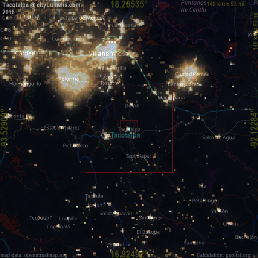
Analysis of Tacotalpa night lights 2016
Square area 10x10 km:
 0.41%
0.41%90-99
0.41%80-89
2.48%70-79
0%60-69
0%50-59
0.83%40-49
1.86%30-39
1.86%20-29
0.83%10-19
0%0-9
91.32%Square area 50x50 km:
0.19%90-99
0.48%80-89
0.65%70-79
0.32%60-69
0.31%50-59
0.67%40-49
1.03%30-39
1.56%20-29
1.75%10-19
3.37%0-9
89.68%Clear (daylight) street map image can be seen on geolist.org.
Map coordinates:
18° 15' 55.3" North, 93° 31' 44.7" West
17° 35' 47" North, 92° 49' 33.5" West
16° 55' 29.7" North, 92° 7' 22.2" West
Some cities around Tacotalpa sort by population:
• Macuspana
30.5 km =19 mi,  53°
53°
• Teapa
14.3 km =8.9 mi,  248°
248°
• Río de Teapa
22.2 km =13.8 mi,  339°
339°
• Playas del Rosario
30.7 km =19.1 mi, 338°
• Pichucalco
32.2 km =20 mi, 252°
• Parrilla II
33 km =20.5 mi, 342°
• Parilla
36.7 km =22.8 mi, 344°
• Belén
31.2 km =19.4 mi, 46°
3516439 (p: 8,071)
Sources (retrieved 2019-11-25):
» Earth at Night: Flat Maps 2012, 2016