Pesquería night lights from space
Night Light of Pesquería (Nuevo León) from space (Mexico) Src. Average luminocity for 10x10km area is 43.5492% and for 50x50km: 38.7015%.
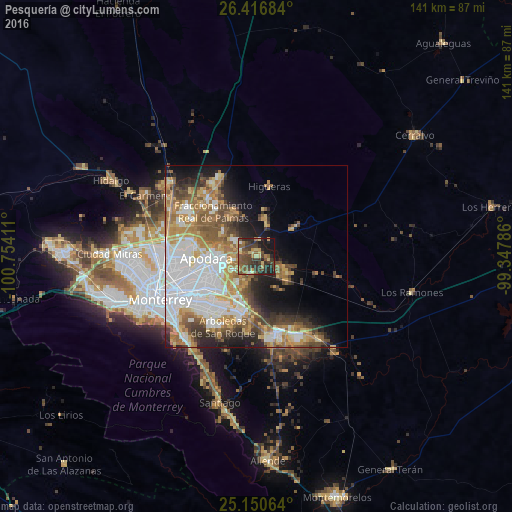
Analysis of Pesquería night lights 2016
Square area 10x10 km:
 0.95%
0.95%90-99
2.08%80-89
8.71%70-79
4.73%60-69
6.44%50-59
13.45%40-49
15.53%30-39
14.2%20-29
16.29%10-19
15.53%0-9
2.08%Square area 50x50 km:
9.86%90-99
7.1%80-89
4.66%70-79
5.65%60-69
6.37%50-59
5.49%40-49
5.02%30-39
4.18%20-29
5.22%10-19
8.56%0-9
37.9%Clear (daylight) street map image can be seen on geolist.org.
Map coordinates:
26° 25' 0.6" North, 100° 45' 14.8" West
25° 47' 7.5" North, 100° 3' 3.5" West
25° 9' 2.3" North, 99° 20' 52.3" West
Some cities around Pesquería sort by population:
• Ciudad Apodaca
13.8 km =8.6 mi,  268°
268°
• Ciudad Benito Juárez
16 km =9.9 mi,  196°
196°
• Fraccionamiento Real Palmas
17.1 km =10.6 mi,  320°
320°
• General Zuazua
13.4 km =8.3 mi,  334°
334°
• Santa Rosa
17.6 km =10.9 mi,  284°
284°
• Prados de Santa Rosa
17.7 km =11 mi, 274°
• Misión San Pablo
10.6 km =6.6 mi,  241°
241°
• Loma la Paz
11.8 km =7.3 mi,  225°
225°
3992857 (p: 5,465)
Sources (retrieved 2019-11-25):
» Earth at Night: Flat Maps 2012, 2016