General Zuazua night lights from space
Night Light of General Zuazua (Nuevo León) from space (Mexico) Src. Average luminocity for 10x10km area is 32.6326% and for 50x50km: 32.8727%.
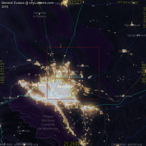
Analysis of General Zuazua night lights 2016
Square area 10x10 km:
 0.76%
0.76%90-99
0.76%80-89
0%70-79
5.3%60-69
7.2%50-59
7.77%40-49
18.75%30-39
8.14%20-29
12.31%10-19
22.73%0-9
16.29%Square area 50x50 km:
9.77%90-99
6%80-89
3.64%70-79
4.75%60-69
5.09%50-59
4.34%40-49
3.85%30-39
2.61%20-29
3.56%10-19
6.69%0-9
49.7%Clear (daylight) street map image can be seen on geolist.org.
Map coordinates:
26° 31' 32.6" North, 100° 48' 40.1" West
25° 53' 41.7" North, 100° 6' 28.8" West
25° 15' 38.5" North, 99° 24' 17.6" West
Some cities around General Zuazua sort by population:
• Ciudad Apodaca
14.9 km =9.3 mi,  212°
212°
• Fraccionamiento Real Palmas
5.3 km =3.3 mi,  281°
281°
• Ciénega de Flores
8.9 km =5.5 mi,  318°
318°
• Santa Rosa
13.8 km =8.6 mi,  235°
235°
• Prados de Santa Rosa
16 km =9.9 mi,  227°
227°
• Real del Sol
8.8 km =5.5 mi,  303°
303°
• Pesquería
13.4 km =8.3 mi,  154°
154°
• Villas de Alcalá
8.1 km =5 mi,  286°
286°
4005856 (p: 9,898)
Sources (retrieved 2019-11-25):
» Earth at Night: Flat Maps 2012, 2016