Loma la Paz night lights from space
Night Light of Loma la Paz (Nuevo León) from space (Mexico) Src. Average luminocity for 10x10km area is 86.8295% and for 50x50km: 48.518%.
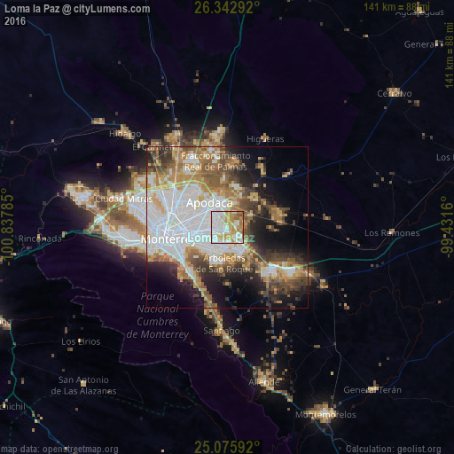
Analysis of Loma la Paz night lights 2016
Square area 10x10 km:
 29.92%
90-99
25%80-89
11.17%70-79
19.7%60-69
9.28%50-59
4.36%40-49
0.57%30-39
0%20-29
0%10-19
0%0-9
0%Square area 50x50 km:
13.8%90-99
9.47%80-89
5.23%70-79
6.58%60-69
6.95%50-59
6.47%40-49
5.78%30-39
5.21%20-29
6.63%10-19
10.93%0-9
22.96%Clear (daylight) street map image can be seen on geolist.org.
Map coordinates:
26° 20' 34.5" North, 100° 50' 16.3" West
25° 42' 40" North, 100° 8' 5" West
25° 4' 33.3" North, 99° 25' 53.8" West
Some cities around Loma la Paz sort by population:
• Guadalupe
12.8 km =8 mi,  252°
252°
• Ciudad Apodaca
9.5 km =5.9 mi,  325°
325°
• Ciudad Benito Juárez
8.1 km =5 mi,  151°
151°
• Jardines de la Silla (Jardines)
10.5 km =6.5 mi,  210°
210°
• Misión San Pablo
3.3 km =2.1 mi,  343°
343°
• Héctor Caballero
8.4 km =5.2 mi,  174°
174°
• Monte Kristal
9.7 km =6 mi,  193°
193°
• Pesquería
11.8 km =7.3 mi,  45°
45°
8858248 (p: 5,629)
Sources (retrieved 2019-11-25):
» Earth at Night: Flat Maps 2012, 2016