Santa Rosa night lights from space
Night Light of Santa Rosa (Nuevo León) from space (Mexico) Src. Average luminocity for 10x10km area is 80.7917% and for 50x50km: 51.5282%.
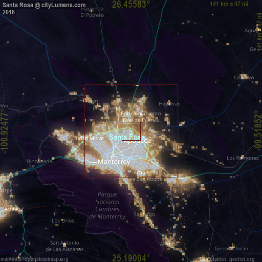
Analysis of Santa Rosa night lights 2016
Square area 10x10 km:
 18.18%
90-99
23.11%80-89
12.31%70-79
16.67%60-69
14.39%50-59
12.88%40-49
2.46%30-39
0%20-29
0%10-19
0%0-9
0%Square area 50x50 km:
15.41%90-99
10.67%80-89
5.56%70-79
7.01%60-69
7.9%50-59
6.56%40-49
5.22%30-39
4.58%20-29
5.53%10-19
9.03%0-9
22.52%Clear (daylight) street map image can be seen on geolist.org.
Map coordinates:
26° 27' 21" North, 100° 55' 29.2" West
25° 49' 28.7" North, 100° 13' 17.9" West
25° 11' 24.1" North, 99° 31' 6.7" West
Some cities around Santa Rosa sort by population:
• Ciudad Apodaca
5.8 km =3.6 mi,  144°
144°
• San Nicolás de los Garza
12.3 km =7.6 mi,  221°
221°
• Ciudad General Escobedo
10.1 km =6.3 mi,  252°
252°
• Fraccionamiento Real Palmas
10.8 km =6.7 mi,  35°
35°
• Prados de Santa Rosa
3 km =1.9 mi,  190°
190°
• Misión San Pablo
12.2 km =7.6 mi, 140°
• Emiliano Zapata
11.2 km =7 mi,  328°
328°
• Villas de Alcalá
10.7 km =6.6 mi,  19°
19°
3983895 (p: 9,880)
Sources (retrieved 2019-11-25):
» Earth at Night: Flat Maps 2012, 2016