Misión San Pablo night lights from space
Night Light of Misión San Pablo (Nuevo León) from space (Mexico) Src. Average luminocity for 10x10km area is 88.553% and for 50x50km: 50.256%.
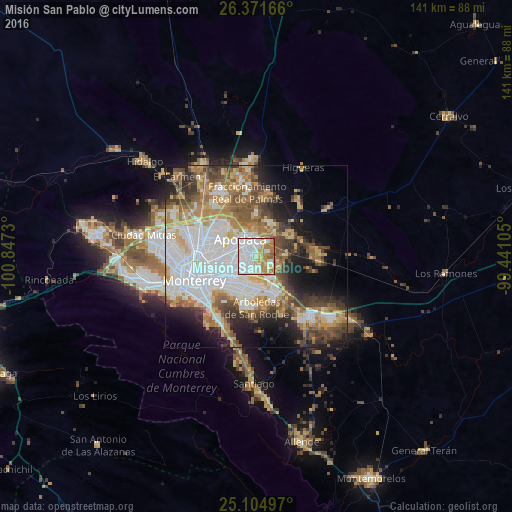
Analysis of Misión San Pablo night lights 2016
Square area 10x10 km:
 35.42%
90-99
25.76%80-89
8.9%70-79
15.72%60-69
10.04%50-59
3.98%40-49
0.19%30-39
0%20-29
0%10-19
0%0-9
0%Square area 50x50 km:
14.14%90-99
9.68%80-89
5.5%70-79
7.06%60-69
7.56%50-59
6.57%40-49
6.11%30-39
5.56%20-29
6.83%10-19
10.43%0-9
20.56%Clear (daylight) street map image can be seen on geolist.org.
Map coordinates:
26° 22' 18" North, 100° 50' 50.3" West
25° 44' 24" North, 100° 8' 39" West
25° 6' 17.9" North, 99° 26' 27.8" West
Some cities around Misión San Pablo sort by population:
• Ciudad Apodaca
6.4 km =4 mi,  316°
316°
• Ciudad Benito Juárez
11.4 km =7.1 mi,  154°
154°
• Santa Rosa
12.2 km =7.6 mi, 320°
• Prados de Santa Rosa
10.5 km =6.5 mi,  307°
307°
• Héctor Caballero
11.7 km =7.3 mi,  171°
171°
• Monte Kristal
12.7 km =7.9 mi,  185°
185°
• Loma la Paz
3.3 km =2.1 mi,  163°
163°
• Pesquería
10.6 km =6.6 mi,  61°
61°
8858184 (p: 8,174)
Sources (retrieved 2019-11-25):
» Earth at Night: Flat Maps 2012, 2016