Tlamacazapa night lights from space
Night Light of Tlamacazapa (Guerrero) from space (Mexico) Src. Average luminocity for 10x10km area is 2.7066% and for 50x50km: 8.7096%.
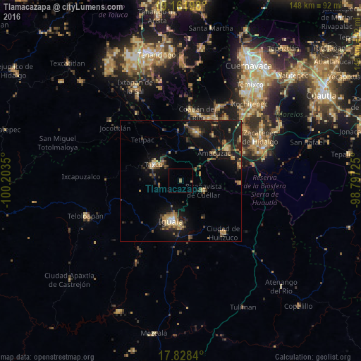
Analysis of Tlamacazapa night lights 2016
Square area 10x10 km:
 0%
0%90-99
0%80-89
0.83%70-79
0%60-69
0.83%50-59
0.83%40-49
0%30-39
0%20-29
0%10-19
0%0-9
97.52%Square area 50x50 km:
0.15%90-99
0.25%80-89
1.3%70-79
1.34%60-69
1.81%50-59
0.82%40-49
1.88%30-39
2.05%20-29
2.54%10-19
9.78%0-9
78.08%Clear (daylight) street map image can be seen on geolist.org.
Map coordinates:
19° 9' 43.1" North, 100° 12' 12.6" West
18° 29' 47.4" North, 99° 30' 1.3" West
17° 49' 42.2" North, 98° 47' 50.1" West
Some cities around Tlamacazapa sort by population:
• Iguala de la Independencia
17.3 km =10.7 mi,  194°
194°
• Taxco de Alarcón
12.9 km =8 mi,  300°
300°
• Puente de Ixtla
23.3 km =14.5 mi,  55°
55°
• La Joya
19.3 km =12 mi,  10°
10°
• Buenavista de Cuéllar
10.5 km =6.5 mi,  112°
112°
• Tepecoacuilco de Trujano
23.5 km =14.6 mi,  170°
170°
• Amacuzac
17.9 km =11.1 mi,  50°
50°
• Acamixtla
10.3 km =6.4 mi,  317°
317°
3515410 (p: 6,234)
Sources (retrieved 2019-11-25):
» Earth at Night: Flat Maps 2012, 2016